
Archivo:Arbitration1898-1902.jpg
Ver la imagen en su resolución original (4832 × 3280 píxeles; tamaño de archivo: 1,9 MB; tipo MIME: image/jpeg)
| Descripción |
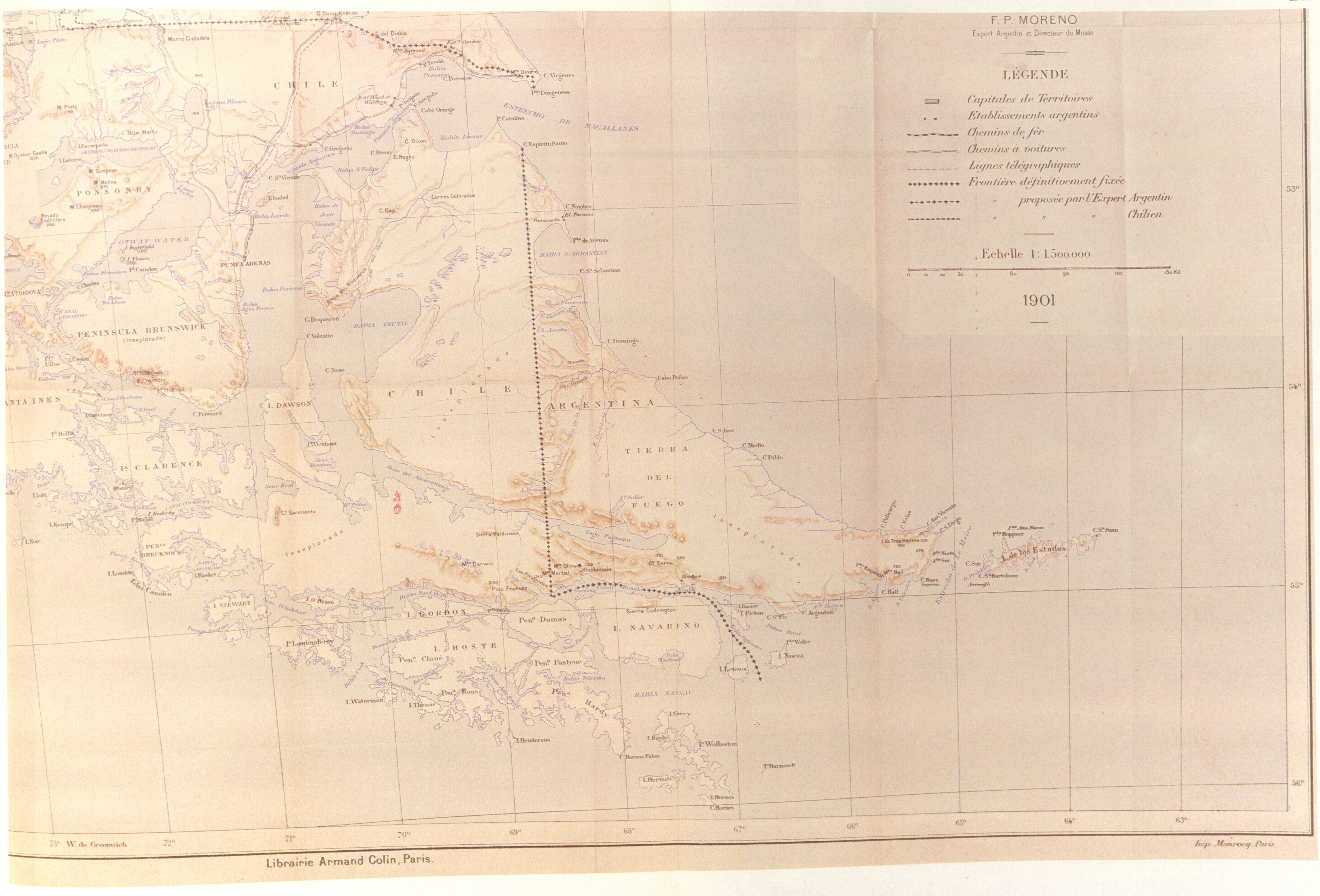
"This partially reproduced map correspond to the called 'Preliminary Map of the Southern Region of the Argentine Republic'which was included as No. XIV in the Argentine Evidence submitted by the Argentine Government to British Arbitration in 1898-1902. It is the first official map of Argentina showing in the area of the Beagle Channel a different frontier from the one established in the Boundary Treaty with Chile of 1881. As may be seen from the map, the boundary line deviates from the Beagle Channel towards Picton and Richmond Passages to end up between Lennox and Nueva Islands. In that way Picton and Nueva Islands appear as Argentine and lennox Island as Chilean. The islands and islets extending southward as far as Cape Horn continue to be shown as under Chilean sovereignty. It should be recalled that there was no question concerning the territories to the south of the Magellan Strait in the British Arbitration of 1898-1902. Thus neither Chile nor Argentina made any specific reference to the boundary shown on the Argentine map reproduced here. " |
||||
| Fecha | |||||
| Fuente | El Conflicto del Beagle, edited by the chilean Foreign Affairs Office, 1978, Switzerland. | ||||
| Autor | F.P.Moreno | ||||
| Permiso (Reutilización de este archivo) |
|
||||
Historial del archivo
Haz clic sobre una fecha y hora para ver el archivo tal como apareció en ese momento.
| Fecha y hora | Miniatura | Dimensiones | Usuario | Comentario | |
|---|---|---|---|---|---|
| actual | 13:43 19 ago 2007 | | 4832 × 3280 (1,9 MB) | Keysanger | {{Information |Description="This partially reproduced map correspond to the called 'Preliminary Map of the Southern Region of the Argentine Republic'which was included as No. XIV in the Argentine Evidence submitted by the Argentine Government to British A |
Usos del archivo
La siguiente página usa este archivo:
Uso global del archivo
Las wikis siguientes utilizan este archivo:
- Uso en de.wikipedia.org
- Uso en en.wikipedia.org
- Uso en fr.wikipedia.org