
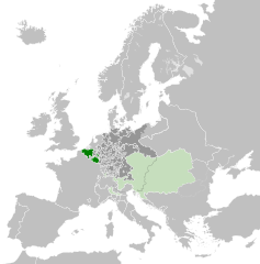
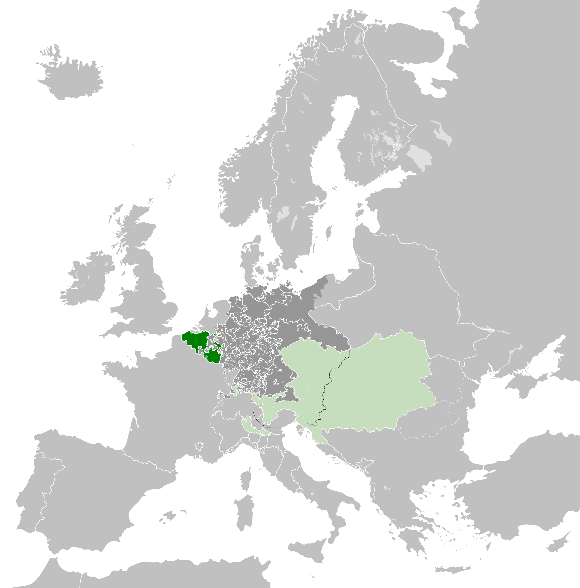
Archivo:Austrian Netherlands 1789.svg

Tamaño de esta previsualización PNG del archivo SVG: 450 × 456 píxeles. Otras resoluciones: 237 × 240 píxeles · 474 × 480 píxeles · 758 × 768 píxeles · 1011 × 1024 píxeles · 2021 × 2048 píxeles.
Ver la imagen en su resolución original ((Imagen SVG, nominalmente 450 × 456 pixels, tamaño de archivo: 858 kB))
Resumen


.svg)
.svg)
.svg)
.svg)
.svg)


.svg)
.svg)
.svg)


.png)
.png)


.svg)


.svg)

.svg)


.svg)
.svg)
.svg)
.svg)


.svg)
.png)


.svg)


.svg)
.svg)


.svg)


.svg)


.svg)
.svg)
.svg)
.svg)
.svg)
.svg)
.svg)
_cropped.svg)
.svg)
.svg)
.svg)
.svg)
.svg)
.svg)
.svg)
.svg)
.svg)
.svg)
.svg)
.svg)
.svg)
.svg)
.svg)
.svg)
.svg)
.svg)
.svg)
.svg)
.svg)
.svg)
.svg)
.svg)
.svg)
.svg)
.svg)
.svg)
.svg)
.svg)
.svg)
.svg)
.svg)
.svg)
.svg)
.svg)
.svg)
.svg)
.svg)
.svg)
.svg)
.svg)
.svg)
.svg)
.svg)
Licencia
Yo, el titular de los derechos de autor de esta obra, la publico en los términos de la siguiente licencia:
Este archivo se encuentra bajo la licencia Creative Commons Genérica de Atribución/Compartir-Igual 3.0.
- Eres libre:
- de compartir – de copiar, distribuir y transmitir el trabajo
- de remezclar – de adaptar el trabajo
- Bajo las siguientes condiciones:
- atribución – Debes otorgar el crédito correspondiente, proporcionar un enlace a la licencia e indicar si realizaste algún cambio. Puedes hacerlo de cualquier manera razonable pero no de manera que sugiera que el licenciante te respalda a ti o al uso que hagas del trabajo.
- compartir igual – En caso de mezclar, transformar o modificar este trabajo, deberás distribuir el trabajo resultante bajo la misma licencia o una compatible como el original.
Registro original de carga
This image is a derivative work of the following images:
- File:Europe_1789.svg licensed with Cc-by-sa-3.0
- 2013-04-14T03:44:26Z Alphathon 450x456 (858577 Bytes) Corrected some errors in northern Italy
- 2013-04-14T01:38:01Z Alphathon 450x456 (853881 Bytes) tweaked again
- 2013-04-14T01:36:10Z Alphathon 450x456 (853881 Bytes) Tweaked Holy Roman Empire border style
- 2013-04-14T01:33:26Z Alphathon 450x456 (853857 Bytes) == {{int:filedesc}} == {{Information |Description={{en|A blank Map of Europe circa 1789. This map also includes a border for the [[:en:Holy Roman Empire|Holy Roman Empire]]. Since there are so many small German states, they h
Uploaded with derivativeFX
Historial del archivo
Haz clic sobre una fecha y hora para ver el archivo tal como apareció en ese momento.
| Fecha y hora | Miniatura | Dimensiones | Usuario | Comentario | |
|---|---|---|---|---|---|
| actual | 07:38 17 oct 2021 | | 450 × 456 (858 kB) | Fenn-O-maniC | Wrong file |
| 07:38 17 oct 2021 |  | 450 × 456 (800 kB) | Fenn-O-maniC | Fixed the Russo-Swedish border to match the Treaty of Åbo of 1743 | |
| 07:36 17 oct 2021 |  | 450 × 456 (858 kB) | Fenn-O-maniC | Fixed the Russo-Swedish border to match the Treaty of Åbo of 1743 | |
| 20:34 18 abr 2013 |  | 450 × 456 (878 kB) | Alphathon | Style change | |
| 18:34 18 abr 2013 |  | 450 × 456 (857 kB) | Alphathon | Various fixes | |
| 20:31 15 abr 2013 |  | 450 × 456 (854 kB) | Alphathon | Corrected Scandinavian borders | |
| 23:18 14 abr 2013 |  | 450 × 456 (839 kB) | Alphathon | Changed colour of the remainder of the Habsburg Monarchy | |
| 13:29 14 abr 2013 |  | 450 × 456 (839 kB) | Alphathon | == {{int:filedesc}} == {{Information |Description={{en|A map of the Austrian Netherlands within the Habsburg Monarchy, the Holy Roman Empire and Europe circa 1789.}}{{de|Eine Landkarte die [[:de:Öste... |
Usos del archivo
La siguiente página usa este archivo:
Uso global del archivo
Las wikis siguientes utilizan este archivo:
- Uso en ar.wikipedia.org
- Uso en ast.wikipedia.org
- Uso en bg.wikipedia.org
- Uso en cs.wikipedia.org
- Uso en en.wikipedia.org
- Uso en eo.wikipedia.org
- Uso en et.wikipedia.org
- Uso en eu.wikipedia.org
- Uso en fa.wikipedia.org
- Uso en fi.wikipedia.org
- Uso en fr.wikipedia.org
- Uso en gl.wikipedia.org
- Uso en he.wikipedia.org
- Uso en id.wikipedia.org
- Uso en is.wikipedia.org
- Uso en it.wikipedia.org
- Uso en ja.wikipedia.org
- Uso en ko.wikipedia.org
- Uso en lv.wikipedia.org
- Uso en mk.wikipedia.org
- Uso en pt.wikipedia.org
- Uso en sl.wikipedia.org
- Uso en th.wikipedia.org
- Uso en tr.wikipedia.org
- Uso en uk.wikipedia.org
- Uso en vi.wikipedia.org
- Uso en www.wikidata.org
- Uso en zh.wikipedia.org