
Archivo:Carrizo Chuska NASA.jpg

Ver la imagen en su resolución original (1850 × 1255 píxeles; tamaño de archivo: 606 kB; tipo MIME: image/jpeg)
Resumen
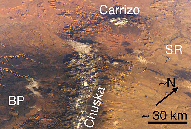
(view due-northwest-note N-arrow)-Carrizo Mountains (Arizona) and Chuska Mountains (Arizona and New Mexico), each with a little snow. Also, two features of the Navajo Volcanic Province: BP Buell Peak, (Arizona)-(at southeast perimeter, Canyon de Chelly), and SR Ship Rock (New Mexico). Cropped, marked, and lower resolution from http://eol.jsc.nasa.gov/ NASA image ISS008-E-5589.
Also, Red Rock Valley is between the two mountain ranges (and is reddish-Ship Rock to the east); in the same alignment with the Chuska trendline-(but north of Carrizos), is Walker Creek-(northeast tributary of Chinle Creek), and Alcove Canyon, both connected to the west & southwest of the Carrizo Mtns; west of the Chuskas is also Canyon de Chelly-(showing eastern canyons/rivercourses); southwest is the Defiance Plateau (Canyon de Chelly at its north terminus-Buell Peak, adjacent southeast, on Defiance Plateau);
Walker Creek is part of the northeast of Chinle Valley.
Note Cloud Shadows; the mountains, or canyons are also making shadows, i.e. an early morning photo, sun in East, or ESEast-(?).
Licencia
| Este archivo es de dominio público porque fue creado por la NASA. Las políticas sobre copyright de la NASA estipulan que «el material de la NASA no está protegido con copyright a menos que se indique lo contrario». (Políticas sobre copyright de la NASA o Políticas sobre la utilización de imágenes del Jet Propulsion Laboratory). | ||
 |
Advertencias:
|
Historial del archivo
Haz clic sobre una fecha y hora para ver el archivo tal como apareció en ese momento.
| Fecha y hora | Miniatura | Dimensiones | Usuario | Comentario | |
|---|---|---|---|---|---|
| actual | 19:33 27 jun 2006 | | 1850 × 1255 (606 kB) | Omphacite~commonswiki | Carrizo Mountains (Arizona) and Chuska Mountains (Arizona and New Mexico), each with a little snow. Also, two features of the Navajo Volcanic Province: BP Buell Park (Arizona), and SR Ship Rock (New Mexico). Cropped, marked, and lower resolution from http |
Usos del archivo
La siguiente página usa este archivo:
Uso global del archivo
Las wikis siguientes utilizan este archivo:
- Uso en en.wikipedia.org