
Archivo:Denmark Zealand location map.svg

Tamaño de esta previsualización PNG del archivo SVG: 361 × 600 píxeles. Otras resoluciones: 144 × 240 píxeles · 289 × 480 píxeles · 462 × 768 píxeles · 616 × 1024 píxeles · 1233 × 2048 píxeles · 602 × 1000 píxeles.
Ver la imagen en su resolución original ((Imagen SVG, nominalmente 602 × 1000 pixels, tamaño de archivo: 249 kB))
Resumen
| Descripción |
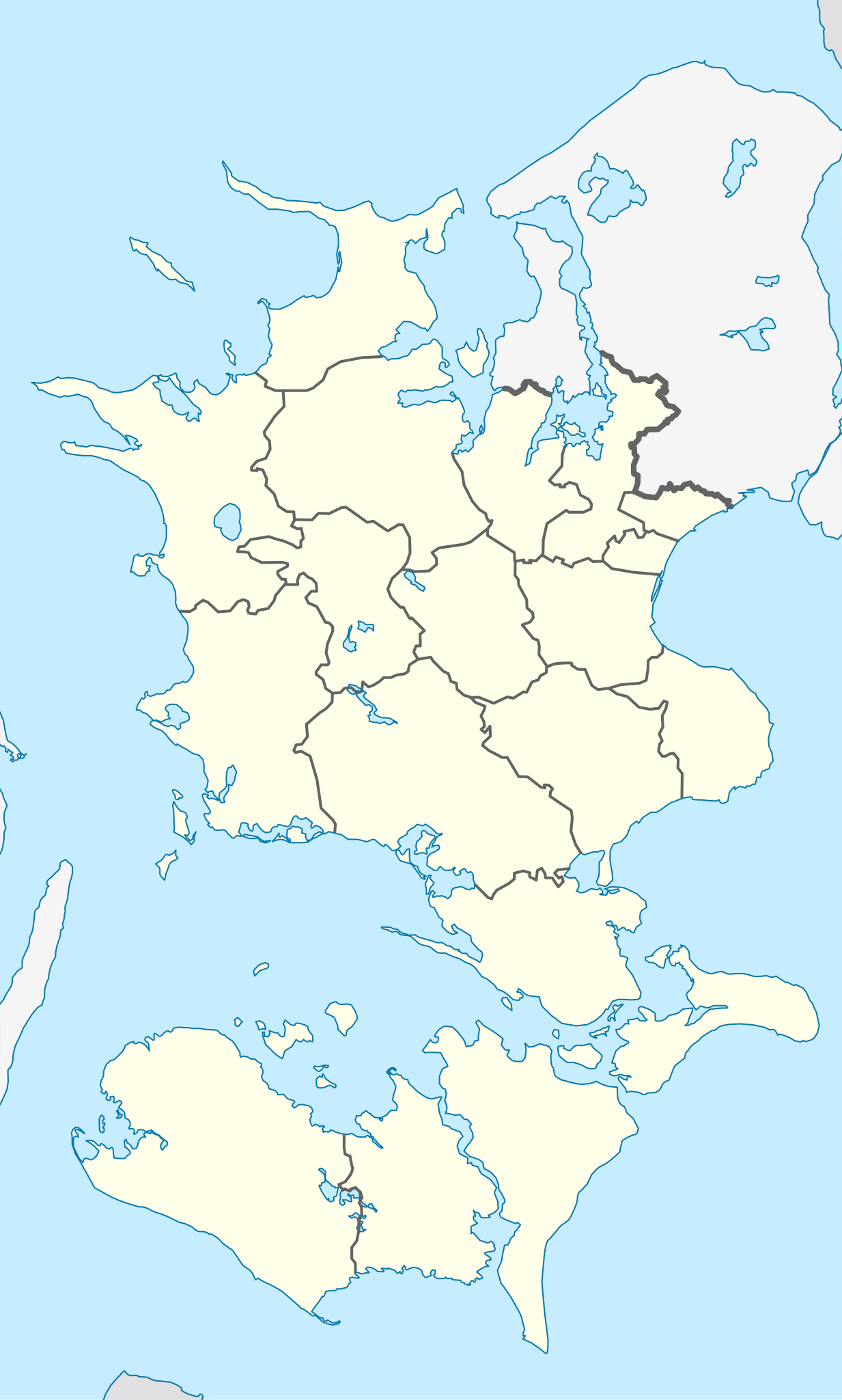
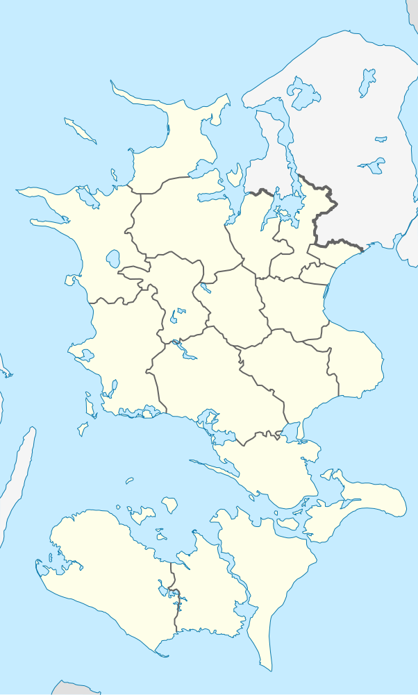
English: Location map of Region Zealand in Denmark
Equirectangular projection, N/S stretching 176 %. Geographic limits of the map:
Deutsch: Positionskarte von der Region Sjæland in Dänemark
Quadratische Plattkarte, N-S-Streckung 176 %. Geographische Begrenzung der Karte:
|
| Fecha | |
| Fuente | Trabajo propio |
| Autor | Erik Frohne |
| SVG desarrollo | El código fuente de esta imagen SVG es inválido por un error. |
Licencia
Yo, titular de los derechos de autor de esta obra, la publico en los términos de las siguientes licencias:

|
Se autoriza la copia, distribución y modificación de este documento bajo los términos de la licencia de documentación libre GNU, versión 1.2 o cualquier otra que posteriormente publique la Fundación para el Software Libre; sin secciones invariables, textos de portada, ni textos de contraportada. Se incluye una copia de la dicha licencia en la sección titulada Licencia de Documentación Libre GNU. |
Este archivo se encuentra bajo la licencia Creative Commons Genérica de Atribución/Compartir-Igual 3.0.
- Eres libre:
- de compartir – de copiar, distribuir y transmitir el trabajo
- de remezclar – de adaptar el trabajo
- Bajo las siguientes condiciones:
- atribución – Debes otorgar el crédito correspondiente, proporcionar un enlace a la licencia e indicar si realizaste algún cambio. Puedes hacerlo de cualquier manera razonable pero no de manera que sugiera que el licenciante te respalda a ti o al uso que hagas del trabajo.
- compartir igual – En caso de mezclar, transformar o modificar este trabajo, deberás distribuir el trabajo resultante bajo la misma licencia o una compatible como el original.
Puedes usar la licencia que prefieras.
Historial del archivo
Haz clic sobre una fecha y hora para ver el archivo tal como apareció en ese momento.
| Fecha y hora | Miniatura | Dimensiones | Usuario | Comentario | |
|---|---|---|---|---|---|
| actual | 13:22 13 ene 2010 | | 602 × 1000 (249 kB) | Erik Frohne | Reverted to version as of 16:15, 14 March 2009:Colors as agreed upon by german and french map makers. Use file Denmark Zealand location map (ca).svg instead if you need other colors |
| 01:37 29 dic 2009 |  | 361 × 600 (635 kB) | Hubertus45 | Changing colour after consensus with other users. | |
| 23:42 14 dic 2009 |  | 361 × 600 (635 kB) | Hubertus45 | Making the region more visible to the neighbour areas. | |
| 23:35 14 dic 2009 |  | 361 × 600 (635 kB) | Hubertus45 | Making the region more visible to the neighbour areas. | |
| 16:15 14 mar 2009 |  | 602 × 1000 (249 kB) | Erik Frohne | {{Information |Description={{en|1=Location map of Region Zealand in Denmark Equirectangular projection, N/S stretching 176 %. Geographic limits of the map: * N: 56.20° N * S: 54.50° N * W: 10.80° E * E: 12.60° E}} {{de|1=Positionskarte von der Regio |
Usos del archivo
La siguiente página usa este archivo:
Uso global del archivo
Las wikis siguientes utilizan este archivo:
- Uso en de.wikipedia.org
- Askø
- Fejø
- Femø
- Agersø
- Omø
- Vejrø
- Sender Kalundborg
- Storstrømsbroen
- Farøbroerne
- Falster
- Bogø
- Sprogø
- Guldborgsund
- Orø
- Stevns
- Wikipedia:Kartenwerkstatt/Positionskarten/Europa
- Vorlage:Positionskarte Dänemark Sjælland
- Gedser Fyr
- Grønsund
- Stevns Klint
- Smålandsfarvandet
- Lilleø
- Skalø
- Rågø
- Rågø Kalv
- Vigsø
- Lindholm (Smålandsfarvandet)
- Suderø (Dänemark)
- Havneø
- Storstrømmen
- Ulvsund
- Langø
- Tærø
- Egholm (Agersø)
- Masnedø
- Farø
- Enø
- Glænø
- Nyord
- Gavnø
- Albuen
- Barneholm
- Enehøje
- Vejlø
- Slotø
- Hyllekrog
- Drummelholm
- Storeager
- Lilleager
- Lindholm (Stege Bugt)
Ver más uso global de este archivo.