
Archivo:Indian stream map.png
Tamaño de esta previsualización: 800 × 575 píxeles. Otras resoluciones: 320 × 230 píxeles · 640 × 460 píxeles · 1024 × 736 píxeles · 1280 × 920 píxeles · 1617 × 1162 píxeles.
Ver la imagen en su resolución original (1617 × 1162 píxeles; tamaño de archivo: 147 kB; tipo MIME: image/png)
Resumen
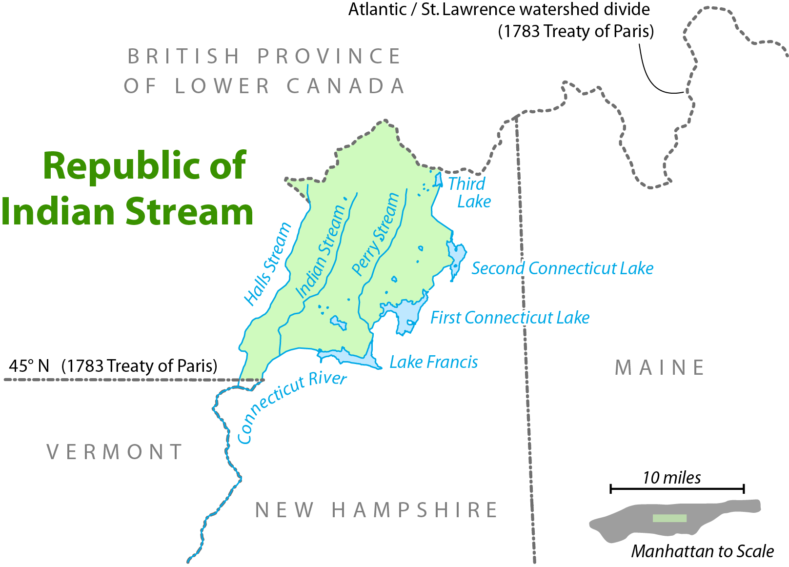
| Descripción | Map showing the location of the Republic of Indian Stream. I, Citynoise, am the creator of this map and hereby release it under the ShareAlike Attribution License. See www.radicalcartography.net for more. |
| Fecha | 18 de junio de 2006 (fecha original de carga) |
| Fuente | Transferido desde en.wikipedia a Commons. |
| Autor |
The original uploader was Citynoise de Wikipedia en inglés. Later versions were uploaded by AnonMoos at en.wikipedia. |

|
Esta imagen debería volverse a crear como imágenes vectoriales SVG. Esto proporciona muchas ventajas, véase Commons:Media for cleanup (en inglés) para más información. Si ya hay una versión SVG de esta imagen disponible, por favor súbala a Commons. Tras subirla, reemplace esta plantilla con la plantilla
{{vector version available|nuevo nombre de imagen.svg}} en esta imagen. |
Licencia
Este archivo se encuentra bajo la licencia Creative Commons Genérica de Atribución/Compartir-Igual 2.5.
- Eres libre:
- de compartir – de copiar, distribuir y transmitir el trabajo
- de remezclar – de adaptar el trabajo
- Bajo las siguientes condiciones:
- atribución – Debes otorgar el crédito correspondiente, proporcionar un enlace a la licencia e indicar si realizaste algún cambio. Puedes hacerlo de cualquier manera razonable pero no de manera que sugiera que el licenciante te respalda a ti o al uso que hagas del trabajo.
- compartir igual – En caso de mezclar, transformar o modificar este trabajo, deberás distribuir el trabajo resultante bajo la misma licencia o una compatible como el original.
Registro original de carga
Aquí se muestra la página de descripción original. Los siguientes nombres de usuario se refieren a en.wikipedia.
- 2006-09-28 11:01 AnonMoos 754×548×8 (92671 bytes) trimming excessive margins (whitespace), increasing PNG compression...
- 2006-06-27 00:48 Citynoise 800×600×8 (115636 bytes) fixed error in date of Treaty of Paris.
- 2006-06-18 03:09 Citynoise 800×600×8 (119474 bytes) Map showing the location of the Republic of Indian Stream. I, Citynoise, am the creator of this map and hereby release it under the ShareAlike Attribution License. See www.radicalcartography.net for more. Added scale.
- 2006-06-18 02:43 Citynoise 800×588×8 (118009 bytes) Map showing the location of the Republic of Indian Stream. I, Citynoise, am the creator of this map and hereby release it under the ShareAlike Attribution License. See www.radicalcartography.net for more.
Historial del archivo
Haz clic sobre una fecha y hora para ver el archivo tal como apareció en ese momento.
| Fecha y hora | Miniatura | Dimensiones | Usuario | Comentario | |
|---|---|---|---|---|---|
| actual | 17:56 6 sep 2016 | | 1617 × 1162 (147 kB) | Citynoise | Corrected name of Lower Canada |
| 17:03 10 abr 2007 |  | 754 × 548 (90 kB) | Liftarn | {{Information |Description=Map showing the location of the Republic of Indian Stream. I, Citynoise, am the creator of this map and hereby release it under the ShareAlike Attribution License. See www.radicalcartography.net for more. |Source=Originally fr |
Usos del archivo
La siguiente página usa este archivo:
Uso global del archivo
Las wikis siguientes utilizan este archivo:
- Uso en ar.wikipedia.org
- Uso en bn.wikipedia.org
- Uso en de.wikipedia.org
- Uso en en.wikipedia.org
- Uso en en.wiktionary.org
- Uso en et.wikipedia.org
- Uso en fr.wikipedia.org
- Uso en ja.wikipedia.org
- Uso en nl.wikipedia.org
- Uso en pt.wikipedia.org
- Uso en ru.wikipedia.org
- Uso en www.wikidata.org
- Uso en zh.wikipedia.org