
Archivo:Metrolinamap.png
No se dispone de una resolución más alta.
Metrolinamap.png (350 × 137 píxeles; tamaño de archivo: 42 kB; tipo MIME: image/png)
Resumen
| Descripción |
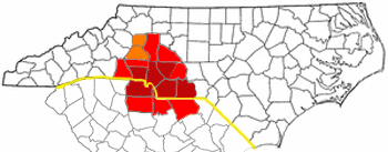
CSA and MSA of the Metrolina area. Adapted from Wikipedia's NC county maps by Seth Ilys. |
| Fecha | 25 de abril de 2006 (fecha original de carga) |
| Fuente | No se ha podido leer automáticamente información sobre la fuente; se asume que es trabajo propio (según los derechos de autor reclamados). |
| Autor | No se ha podido leer automáticamente información sobre el autor; se asume que es Gooday.1~commonswiki (según los derechos de autor reclamados). |
Licencia
| Yo, el titular de los derechos de autor de esta obra, lo libero al dominio público. Esto aplica en todo el mundo. En algunos países esto puede no ser legalmente factible; si ello ocurriese: Concedo a cualquier persona el derecho de usar este trabajo para cualquier propósito, sin ningún tipo de condición al menos que éstas sean requeridas por la ley. |
Historial del archivo
Haz clic sobre una fecha y hora para ver el archivo tal como apareció en ese momento.
| Fecha y hora | Miniatura | Dimensiones | Usuario | Comentario | |
|---|---|---|---|---|---|
| actual | 04:21 29 dic 2006 | 350 × 137 (42 kB) | Gooday.1~commonswiki | CSA and MSA and Charlotte USA of the Metrolina area. Adapted from Wikipedia's NC county maps by Seth Ilys. | |
| 04:12 22 oct 2006 | 350 × 137 (47 kB) | Gooday.1~commonswiki | More asthetically pleasing map of the Charlotte metro area (Metrolina). Red is the most commonly accepted Metrolina area. Orange shows areas sometimes included. MSA and CSA have been left out due to their conflicting representation and overlying other reg | ||
| 03:50 25 abr 2006 | 300 × 117 (34 kB) | Gooday.1~commonswiki | CSA and MSA of the Metrolina area. Adapted from Wikipedia's NC county maps by Seth Ilys. |
Usos del archivo
La siguiente página usa este archivo:
Uso global del archivo
Las wikis siguientes utilizan este archivo:
- Uso en de.wikipedia.org
- Uso en en.wikipedia.org
- User talk:BobbyAFC
- User talk:SQFreak
- User talk:Blackcats
- User talk:Jdb1972
- User talk:Wikipedianinthehouse
- User talk:Fife Club
- User talk:Shizane
- User talk:Grinning Fool
- User talk:Aegreen
- User talk:Baseball Bugs/Archive002
- Wikipedia:WikiProject Charlotte
- User talk:Toa Nidhiki05/Archive 5
- Wikipedia:WikiProject Charlotte/welcome
- User talk:Washuotaku/Archive 2012
- Uso en fr.wikipedia.org
- Uso en it.wikivoyage.org
- Uso en pl.wikipedia.org
- Uso en ur.wikipedia.org
- Uso en www.wikidata.org