
Archivo:Mitchell & Stealey Map of Mexico 1847 UTA (Map of Mexico).jpg
Ver la imagen en su resolución original (2782 × 2057 píxeles; tamaño de archivo: 6,62 MB; tipo MIME: image/jpeg)
Resumen
| Título |
English: Map of Mexico, including Yucatan & Upper California exhibiting the chief cities and towns, the principal traveling routes &c. |
||||||||||||||||||||||||||
| Descripción |
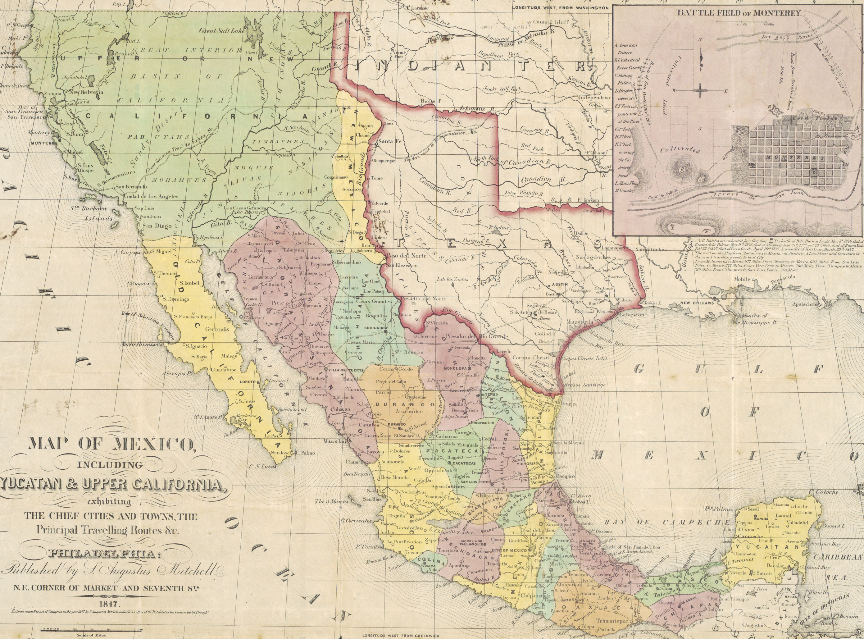
English: The Mitchell mapmaking firm in Philadelphia produced several different maps showing aspects of the U.S. War with Mexico. This vertically oriented map of Mexico, Yucatan, and Upper California actually consists of four separate maps on one sheet designed to inform the public about the geography of the areas most affected by the conflict. A fine outline rendering of the recently-annexed former republic of Texas includes eastern New Mexico and with the republic's "stovepipe" panhandle extending into parts of present Colorado and Wyoming. The map shows the Santa Fe Trail as the "Trader's route to Independence, Mo.," the old "Camino Real" to Chihuahua or Chihuahua Trail, and the "Camino Real" or "old San Antonio Road" from Natchitoches to "Presidio del Rio Grande." A road from Goliad leads south through Refugio to Corpus Christi to Pt. Isabel to Brazos Santiago through the battlefields at Palo Alto and Resaca de la Palma to Matamoras – all points important in the opening and supply phases of U.S. Army General Zachary Taylor's northern campaign. Further west in Upper California may be seen the coastal road and the "Great Spanish Trail to Santa Fe." There is nothing as yet indicated from General Kearny's overland trek to California.
South of the Rio Grande there is more evidence of Taylor's northern campaign by the emphasis on the road from Matamoras to Camargo, Mier, Seralvo [sic, Serralvo], Marine [sic, Marin], and Monterey [sic, Monterrey]. Yet more follows with roads from Monterrey to Rinconada, Saltillo, Buena Vista, Agua Nueva, Encarnacion, and beyond. All of these towns were mentioned in reports emanating from Taylor's campaign in 1846-1847. The old Camino Real extending from San Antonio and the Alamo to Presidio del Rio Grande to Monclova to Saltillo was the route followed by General John E. Wool on a march with the largely U.S. Volunteer "Central Division" to reinforce Taylor. Roads from Matamoras and Monterrey lead off to Tampico where General William Jenkins Worth's Division of Regulars and, later, Patterson's Division of Volunteers withdrew in preparation for the invasion of Central Mexico. Even the rendezvous site of Lobos Island appears — an otherwise insignificant location to show on a general map. The inset at upper right shows the "Battle Field of Monterey" with a plan of the city and small lines indicating the "Route of Gen. Worth's Div[ision]" on the 20th of September 1846 and the "Route of the 1st Div[ision] and Vol[unteer]s" on the 21st. Variations of this plan appeared in illustrated newspapers, reports, and other accounts of the time. The bottom of the sheet features George Stealey's Map of the Principal Roads from Vera Cruz and Alvarado to the City of Mexico, Including the Valley of Mexico, Mountains, Plains, Volcanoes, Lakes &c. This area encompassed General Winfield Scott's Central Campaign in Mexico and much of the map and even the idea for the profile elevations below derived from Alexander von Humboldt. A hand-drawn red line indicates General Scott's route from Veracruz to the National Bridge, Cerro Gordo, "El Encerno" [sic, El Encerro, one of Santa Anna's haciendas], Jalapa, Perote, Puebla, to Mexico City. This, the map notes is the "Main Road from Veracruz to Mexico…Stagecoaches run through in 3 days." (Scott and the U.S. Army had to fight their way over this route in just over six months, from March 9 to September 14, 1847.) Stealey also took care to include the routes of Hernan Cortes' conquest in 1519, 1520, and 1521, as well as roads from Mexico City to Tampico, Oaxaca, and Acapulco. It is interesting to note that this particular map apparently once belonged to Lieutenant D. T. Van Buren of the 2nd Artillery, according to an inscription on the back. Daniel Thompkins Van Buren (1826-1890) was a New York native and West Point graduate who participated in the final battles for and occupation of Mexico City. He eventually rose to the rank of Brevet Brigadier General for the Union during the Civil War. Van Buren's ink annotations along the route from Veracruz to Mexico City declare that from the high road near Jalapa, one "Can see the Gulf from here" and note the location of the "Castle" at Perote. Near the decorative Mexican eagle grappling a serpent appears to be Van Buren's notes about his return to the U.S. at the end of the war: "left Mexico 20th May 1848 / at Vera Cruz 14th June [1848] / [at] N[ew] Orleans 28th June [1848]." Far to the north along the Rio Grande in New Mexico is a handwritten "Jornada del Muerto" – perhaps a cryptic reference to the march of the Missouri Volunteers under Colonels A. W. Doniphan or Sterling Price. |
||||||||||||||||||||||||||
| Fecha | |||||||||||||||||||||||||||
| Fuente | UTA Libraries Cartographic Connections: mapa / texto | ||||||||||||||||||||||||||
| Creador |
|
||||||||||||||||||||||||||
| Adquisición |
English: The University of Texas at Arlington Libraries Special Collections |
||||||||||||||||||||||||||
| Geotemporal data | |||||||||||||||||||||||||||
| Map location | México | ||||||||||||||||||||||||||
| Georeferencing | If inappropriate please set warp_status = skip to hide. | ||||||||||||||||||||||||||
| Bibliographic data | |||||||||||||||||||||||||||
| Lugar de publicación | Filadelfia | ||||||||||||||||||||||||||
| Editorial |
S. Augustus Mitchell & Co. |
||||||||||||||||||||||||||
| Impreso por |
|
||||||||||||||||||||||||||
| Archival data | |||||||||||||||||||||||||||
| Colección |
|
||||||||||||||||||||||||||
| Dimensiones | altura: 83 cm; ancho: 60,5 cm | ||||||||||||||||||||||||||
| Técnica | litógrafo coloreado sobre papel | ||||||||||||||||||||||||||
| Inscripciones |
English: Map of the Principal Roads from Vera Cruz and Alvarado to the City of Mexico, Including the Valley of Mexico, Mountains, Plains, Volcanoes, Lakes &c. Compiled from the latest and best authorities by Geo. Stealey, Civil Engineer [and] Profile of the Road between Mexico and Vera Cruz. |
||||||||||||||||||||||||||
| artwork-references |
Huseman, Ben W. (2018) Paths to Highways: Routes of Exploration, Commerce, and Settlement, Arlington: The University of Texas at Arlington Libraries, nº34 , pp. 29–30 Streeter, Thomas W. (1983) Bibliography of Texas, 1795-1845 (2nd ed.), Woodbridge: Research Publications, Inc., nº3868, 3869 «Rev. and enlarged by Archibald Hanna with a Guide to the Microfilm Collection. Reprint edition.» Heitman, Francis R. (1994) Historical Register and Dictionary of the United States Army, 1798-1903, 1, Baltimore: Genealogical Publishing Co., Inc., p. 980 «Originally published in Washington, D.C., 1903.» Huseman, Ben W. (2008) The Price of Manifest Destiny: Maps Relating to Wars in the Southwest Borderlands, 2, Arlington: The University of Texas at Arlington Libraries, nº50 , p. 27 |
||||||||||||||||||||||||||
| Otras versiones | |||||||||||||||||||||||||||

.jpg?uselang=es)
Licencia

|
This file was provided to Wikimedia Commons by the University of Texas at Arlington Libraries as part of a cooperation project. The University of Texas at Arlington Libraries is part of the University of Texas at Arlington, a public research university located in Arlington, Texas.
|
|
Este material está en dominio público en los demás países donde el derecho de autor se extiende por 100 años (o menos) tras la muerte del autor. Esta obra está en el dominio público en los Estados Unidos porque fue publicada (o registrada con la Oficina del Derecho de Autor de los E.E. U.U.) antes del 1 de enero de 1929. | |
| Esta obra ha sido identificada como libre de las restricciones conocidas en virtud del derecho de autor, incluyendo todos los derechos conexos. | |
Historial del archivo
Haz clic sobre una fecha y hora para ver el archivo tal como apareció en ese momento.
| Fecha y hora | Miniatura | Dimensiones | Usuario | Comentario | |
|---|---|---|---|---|---|
| actual | 21:41 30 jul 2019 | | 2782 × 2057 (6,62 MB) | Michael Barera | File:Mitchell & Stealey Map of Mexico 1847 UTA.jpg cropped 7 % horizontally, 50 % vertically using CropTool with precise mode. |
Usos del archivo
La siguiente página usa este archivo:
Uso global del archivo
Las wikis siguientes utilizan este archivo:
- Uso en en.wikipedia.org
.jpg)