
Archivo:RomanFortsNorthernScotland.gif
No se dispone de una resolución más alta.
RomanFortsNorthernScotland.gif (520 × 310 píxeles; tamaño de archivo: 12 kB; tipo MIME: image/gif)
Resumen
| Descripción |
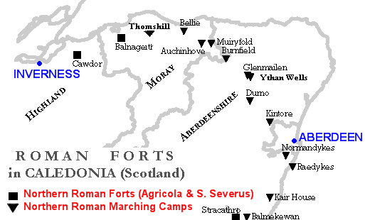
English: Map of Northern Caledonia (Scotland) showing Roman Forts and Marching Camps (little forts) during the Agricola Campaign (first century) and the Septimius Severus Campaign (third century). Map and data done with my own software. |
| Fecha | |
| Fuente | Trabajo propio |
| Autor | Paul0559 |
Licencia
| Yo, el titular de los derechos de autor de esta obra, lo libero al dominio público. Esto aplica en todo el mundo. En algunos países esto puede no ser legalmente factible; si ello ocurriese: Concedo a cualquier persona el derecho de usar este trabajo para cualquier propósito, sin ningún tipo de condición al menos que éstas sean requeridas por la ley. |
Historial del archivo
Haz clic sobre una fecha y hora para ver el archivo tal como apareció en ese momento.
| Fecha y hora | Miniatura | Dimensiones | Usuario | Comentario | |
|---|---|---|---|---|---|
| actual | 02:54 25 jul 2009 | | 520 × 310 (12 kB) | Paul0559 | {{Information |Description={{en|1=Map of Northern Caledonia (Scotland) showing Roman Forts and Marching Camps (little forts) during the Agricola Campaign (first century) and the Septimius Severus Campaign (third century). Map and data done with my own sof |
Usos del archivo
La siguiente página usa este archivo:
Uso global del archivo
Las wikis siguientes utilizan este archivo:
- Uso en en.wikipedia.org
- Uso en it.wikipedia.org
- Vallo Antonino
- Battaglia del monte Graupio
- Campagne in Britannia di Agricola
- Gask Ridge
- Cawdor (accampamento romano)
- Forti e accampamenti romani a nord del Gask Ridge
- Raedykes
- Stracathro
- Balnageith
- Glenmailen
- Ythan Wells
- Muiryfold
- Auchinhove
- Thomshill
- Bellie
- Normandykes
- Balmakewan
- Template:Conquista romana della Caledonia settentrionale
- Kair House
- Kintore (Regno Unito)