
Archivo:Utah Territory, vector image - 2011.svg

Tamaño de esta previsualización PNG del archivo SVG: 280 × 160 píxeles. Otras resoluciones: 320 × 183 píxeles · 640 × 366 píxeles · 1024 × 585 píxeles · 1280 × 731 píxeles · 2560 × 1463 píxeles.
Ver la imagen en su resolución original ((Imagen SVG, nominalmente 280 × 160 pixels, tamaño de archivo: 15 kB))
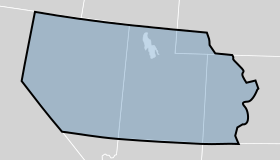
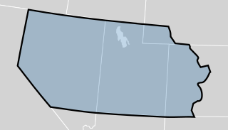
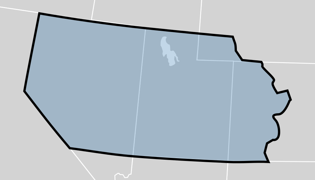
| Descripción | The Utah Territory shown as established by the United States Congress in 1850. The map is underlaid with a modern map of the United States showing the current state boundaries. The territory's boundaries may not be exact. |
| Fecha | (UTC) |
| Fuente | |
| Autor |
|
_-_Geographicus_-_UtahNewMexico-colton-1855.jpg)
Yo, titular de los derechos de autor de esta obra, la publico en los términos de las siguientes licencias:
| Este archivo se encuentra bajo la licencia Creative Commons Genérica de Atribución/Compartir-Igual 3.0. | ||
| ||
| Esta etiqueta de licencia fue agregada a este archivo como parte de la actualización de la licencia GFDL. |

|
Se autoriza la copia, distribución y modificación de este documento bajo los términos de la licencia de documentación libre GNU, versión 1.2 o cualquier otra que posteriormente publique la Fundación para el Software Libre; sin secciones invariables, textos de portada, ni textos de contraportada. Se incluye una copia de la dicha licencia en la sección titulada Licencia de Documentación Libre GNU. |
Puedes usar la licencia que prefieras.
Registro original de carga
This image is a derivative work of the following images:
- File:Blank_US_Map.svg licensed with Cc-by-sa-3.0-migrated, GFDL
- 2009-11-05T19:44:02Z NuclearVacuum 959x593 (91518 Bytes) minor fix from previous upload
- 2009-11-05T19:39:42Z NuclearVacuum 959x593 (88399 Bytes) Fixed up the borders so they are connected with each state and loosing that gap between them.
- 2008-10-09T16:36:40Z Howcheng 959x593 (80121 Bytes) Reverted to version as of 08:32, 14 June 2007
- 2008-03-12T00:20:02Z AMK1211 959x593 (174744 Bytes) Added borders: Light blue for water borders and black for land borders (international borders thicker).
- 2007-06-14T08:32:47Z Fibonacci 959x593 (80121 Bytes) Optimised code.
- 2006-07-12T23:00:30Z Theshibboleth 959x593 (90537 Bytes) The line framework around Alaska and Hawaii has been pushed a bit
- 2006-07-12T06:35:19Z Theshibboleth 959x593 (89828 Bytes) added DC
- 2006-07-12T06:05:05Z Theshibboleth 959x593 (89649 Bytes) {{Information |Description=A blank map of the United States in scalable vector form. |Source=Own work, based on [[:Image:Electorial map.svg]], inspired by [[:Image:BlankMap-World.png]] |Date=11 July 2006 |Author=[[User:Theshi
Historial del archivo
Haz clic sobre una fecha y hora para ver el archivo tal como apareció en ese momento.
| Fecha y hora | Miniatura | Dimensiones | Usuario | Comentario | |
|---|---|---|---|---|---|
| actual | 23:49 17 jul 2012 | | 280 × 160 (15 kB) | Mangoman88 | Fix border along the 37th parallel north |
| 22:20 14 ago 2011 |  | 280 × 160 (14 kB) | Mangoman88 | {{Information |Description=The {{w|Utah Territory}} shown as established by the United States Congress in 1850. The map is underlaid with a modern map of the United States showing the current state boundaries. The territory's boundaries may not be exact. |
Usos del archivo
La siguiente página usa este archivo:
Uso global del archivo
Las wikis siguientes utilizan este archivo:
- Uso en cs.wikipedia.org
- Uso en en.wikipedia.org
- Uso en fa.wikipedia.org
- Uso en he.wikipedia.org
- Uso en it.wikipedia.org
- Uso en ko.wikipedia.org
- Uso en no.wikipedia.org
- Uso en sv.wikipedia.org
- Uso en vi.wikipedia.org
- Uso en zh.wikipedia.org