Archivo:1744 Wren Map of London, England - Geographicus - London-wren-1744.jpg
Contenido de la página no disponible en otros idiomas.
De Wikipedia, la enciclopedia libre

Ver la imagen en su resolución original(5000 × 3496 píxeles; tamaño de archivo: 4,43 MB; tipo MIME: image/jpeg)

Christopher Wren: Ichnographia urbis Londinii… (A Plan of the City of London, after the great FIRE, in the Year of Our Lord 1666.)   (Wikidata search (Cirrus search) Wikidata query (SPARQL)  Create new Wikidata item based on this file)
Artista
Christopher Wren  (1632–1723)  wikidata:Q170373 s:en:Author:Christopher Michael Wren q:en:Christopher Wren
 
Christopher Wren
Nombres alternativos
Sir Christopher Wren
Descripción arquitecto, astrónomo, matemático, físico, anatomista y profesor universitario británico
Fecha de nacimiento/muerte 20 de octubre de 1632 (según el calendario julianoVer y modificar los datos en Wikidata 25 de febrero de 1723 (según el calendario julianoVer y modificar los datos en Wikidata
Lugar de nacimiento/muerte East Knoyle Londres
Período de trabajo 1657-1710
Lugar de trabajo
Control de autoridades
artist QS:P170,Q170373
Título
Ichnographia urbis Londinii… (A Plan of the City of London, after the great FIRE, in the Year of Our Lord 1666.)
Descripción
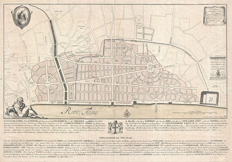
English: An extremely scarce 1744 map of London showing Sir Christopher Wren's plan for reconstructing the city following the 1666 Great Fire of London. In 1666 the Great Fire swept through the old Roman portions of London, laying waste to most of the original walled city. Christopher Wren, a well known architect of the period was quick to respond to the disaster as a opportunity to dramatically redesign and modernize London's center. Wren having been schooled in Paris envisioned an elaborate classically influenced reconstruction of the city with broad avenues meeting in a series of Piazzas. Despite, or perhaps because of, Wren's promptitude in producing a plan for a major post-fire reconstruction, his plan exhibits a number of dramatic errors. Wren did not take the city's topography into account and consequently much of the this plan is unfeasible. Despite claims to the contrary in the document itself, Wren's plan was never seriously considered by either the King or the Parliament. Today Wren's original 1666 plan is lost. This version was drawn in 1744 by the once fashionable engrave P. Fourdrinier, who claims to have replicated exactly a scarce 1724 original owned by the Earl of Pembroke. This map covers London along the north side of the Thames River from Strand Bridge to Great Tower Hill. Shows Wren's detailed reconstruction plan, along with the regions originally destroyed by the Great Fire. Identifies the proposed locations of parochial churches, markets, piazzas, bridges and warehouses. A vignette in the lower left quadrant depicts Thamesis, the river god for which the Thames River is named. The upper left quadrant bears the image of a phoenix, suggesting that, like the mythical bird, London too would rise from its own ashes and be reborn in fire. The lower quadrants of this plate include the map's title in both English and Latin as well as a detailed Explanation of the Plan. This plan is highly uncommon and rarely appears outside of institutional collections.
Fecha 1744 (dated)
Dimensiones altura: 19 in (48,2 cm); ancho: 27,5 in (69,8 cm)
dimensions QS:P2048,19U218593
dimensions QS:P2049,27.5U218593
Número de inventario
Geographicus link: London-wren-1744
Fuente/fotógrafo
Permiso
(Reutilización de este archivo)
Esta es una reproducción fotográfica fiel de una obra de arte bidimensional de dominio público. La obra de arte misma se halla en el dominio público por el motivo siguiente:
Public domain

Este material está en dominio público en los demás países donde el derecho de autor se extiende por 100 años (o menos) tras la muerte del autor.


También debes incluir una etiqueta de dominio público de los Estados Unidos para indicar por qué esta obra está en el dominio público en los Estados Unidos.
La postura oficial de la Fundación Wikimedia considera que «las reproducciones fieles de obras de arte bidimensionales de dominio público forman parte del dominio público».
Esta reproducción fotográfica, por ende, también se considera de dominio público dentro de los Estados Unidos. Es posible que otras jurisdicciones restrinjan la reutilización de este contenido; consúltese Reutilización de fotografías PD-Art (en inglés) para más detalles.
Public domain
Esta obra está en el dominio público en los Estados Unidos porque fue publicada (o registrada con la Oficina del Derecho de Autor de los E.E. U.U.) antes del 1 de enero de 1929.

Los trabajos en el dominio público deben haber expirado su copyright en los Estados Unidos y en el país de origen para ser subidos a Commons. Si el trabajo no es un trabajo estadounidense, el archivo debe tener una marca de derechos de autor adicional indicando el estatus del copyright del país de origen.

Leyendas

Añade una explicación corta acerca de lo que representa este archivo

Elementos representados en este archivo

representa a

image/jpeg

aac4573c33ddccb69d1cadc3765e753878fd91b4

4 649 137 byte

3496 píxel

5000 píxel

Historial del archivo

Haz clic sobre una fecha y hora para ver el archivo tal como apareció en ese momento.

Fecha y horaMiniaturaDimensionesUsuarioComentario
actual20:42 23 mar 2011Miniatura de la versión del 20:42 23 mar 20115000 × 3496 (4,43 MB)BotMultichillT{{subst:User:Multichill/Geographicus |link=http://www.geographicus.com/P/AntiqueMap/London-wren-1744 |product_name=1744 Wren Map of London, England |map_title=Ichnographia urbis Londinii… (A Plan of the City of London, after the great FIRE, in the Year

La siguiente página usa este archivo:

Uso global del archivo

Las wikis siguientes utilizan este archivo: