Archivo:1806 Cary Map of Tartary or Central Asia - Geographicus - Tartary-cary-1806.jpg

Contenido de la página no disponible en otros idiomas.
De Wikipedia, la enciclopedia libre

Ver la imagen en su resolución original(5000 × 4569 píxeles; tamaño de archivo: 8,57 MB; tipo MIME: image/jpeg)

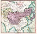
John Cary: A New Map of Mongolian & Independent Tartary , From the Latest Authorities.   (Wikidata search (Cirrus search) Wikidata query (SPARQL)  Create new Wikidata item based on this file)
Artista
John Cary  (–1835)  wikidata:Q3446124 s:en:Author:John Cary
 
Nombres alternativos
John Cary of Cheshire
Descripción cartógrafo, grabador, mapseller, printseller y artista gráfico
Fecha de nacimiento/muerte 23 de febrero de 1755 / 1754 Ver y modificar los datos en Wikidata 16 de agosto de 1835 Ver y modificar los datos en Wikidata
Lugar de nacimiento/muerte Corsley Mortlake
Período de trabajo 1788 / 1793 / 1797 Ver y modificar los datos en Wikidata
Lugar de trabajo
Control de autoridades
artist QS:P170,Q3446124
Título
A New Map of Mongolian & Independent Tartary , From the Latest Authorities.
Descripción
English: An exceptionally beautiful example of John Cary’s important 1806 map of Mongolian and Independent Tartary. Covers Central Asia from the Caspian Sea to Japan, extends as far north as the Obskaia Sea and as far south as India, Burma and the Philippines. Includes the modern day nations of Uzbekistan, Kazakhstan, Turkmenistan, Kirgizstan, Tajikistan and Mongolia. One of Cary’s most interesting maps. Central Asia, despite hundreds of years of passing trade on the Silk Routes, was still, at the turn of the century a largely unknown land. Cary attempts to show some of the Silk Route passages, especially to the north of the Gobi, but ultimately admits, “The Geography of these parts is extremely obscure.” All in all, one of the most interesting and few maps of Central Asia to appear in first years of the 19th century. Prepared in 1806 by John Cary for issue in his magnificent 1808 New Universal Atlas. (NOTE: The reproduction of the colors in this map appear to be incorrect, as Japan and Tibet were never part of Chinese Tartary yet appear to be the same color as it.)
Fecha 1806 (dated)
Dimensiones altura: 18,5 in (46,9 cm); ancho: 20 in (50,8 cm)
dimensions QS:P2048,18.5U218593
dimensions QS:P2049,20U218593
Número de inventario
Geographicus link: Tartary-cary-1806
Fuente/fotógrafo

Cary, John, Cary's New Universal Atlas, containing distinct maps of all the principal states and kingdoms throughout the World. From the latest and best authorities extant. London: Printed for J. Cary, Engraver and Map-seller, No. 181, near Norfolk Street, Strand, 1808.

Permiso
(Reutilización de este archivo)
Esta es una reproducción fotográfica fiel de una obra de arte bidimensional de dominio público. La obra de arte misma se halla en el dominio público por el motivo siguiente:
Public domain

Este material está en dominio público en los demás países donde el derecho de autor se extiende por 100 años (o menos) tras la muerte del autor.


También debes incluir una etiqueta de dominio público de los Estados Unidos para indicar por qué esta obra está en el dominio público en los Estados Unidos.
La postura oficial de la Fundación Wikimedia considera que «las reproducciones fieles de obras de arte bidimensionales de dominio público forman parte del dominio público».
Esta reproducción fotográfica, por ende, también se considera de dominio público dentro de los Estados Unidos. Es posible que otras jurisdicciones restrinjan la reutilización de este contenido; consúltese Reutilización de fotografías PD-Art (en inglés) para más detalles.
Otras versiones
Annotations
InfoField
This image is annotated: View the annotations at Commons

Leyendas

Añade una explicación corta acerca de lo que representa este archivo

Elementos representados en este archivo

representa a

image/jpeg

3d7f1be3ae7a9539d26d91394bee37e7dc951779

8 990 511 byte

4569 píxel

5000 píxel

Historial del archivo

Haz clic sobre una fecha y hora para ver el archivo tal como apareció en ese momento.

Fecha y horaMiniaturaDimensionesUsuarioComentario
actual08:56 19 ago 2019Miniatura de la versión del 08:56 19 ago 20195000 × 4569 (8,57 MB)SoerfmBrightness, color
10:56 22 mar 2011Miniatura de la versión del 10:56 22 mar 20115000 × 4569 (7,81 MB)BotMultichillT{{subst:User:Multichill/Geographicus |link=http://www.geographicus.com/P/AntiqueMap/Tartary-cary-1806 |product_name=1806 Cary Map of Tartary or Central Asia |map_title=A New Map of Chinese & Independent Tartary , From the Latest Authorities. |description=

La siguiente página usa este archivo:

Uso global del archivo

Las wikis siguientes utilizan este archivo:

Metadatos