
Archivo:Burmese-Siamese war (1765-1767) map - EN - 001.jpg

Tamaño de esta previsualización: 342 × 599 píxeles. Otras resoluciones: 137 × 240 píxeles · 274 × 480 píxeles · 438 × 768 píxeles · 584 × 1024 píxeles · 1516 × 2657 píxeles.
Ver la imagen en su resolución original (1516 × 2657 píxeles; tamaño de archivo: 461 kB; tipo MIME: image/jpeg)
Resumen
| Descripción |
English:
ไทย:
|
| Fecha | |
| Fuente |
Trabajo propio
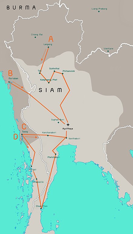
Terwiel, Bertrand. Thailand's Political History: From the 13th Century to Recent Times. Approximate boundaries of the six states that formed after Ayutthaya's destruction. |
| Autor | Aristitleism |
| Otras versiones |
_map_-_TH_-_002.jpg) |
Licencia
Yo, el titular de los derechos de autor de esta obra, la publico en los términos de la siguiente licencia:
| Este archivo está disponible bajo la licencia Creative Commons Dedicación de Dominio Público CC0 1.0 Universal. | |
| La persona que ha asociado una obra a este documento lo dedica al dominio público mediante la cesión mundial de sus derechos bajo la ley de derechos de autor y todos los derechos legales adyacentes propios de dicha, en el ámbito permitido por ley. Puedes copiar, modificar, distribuir y reproducir el trabajo, incluso con objetivos comerciales, sin pedir aprobación del autor.
|
en:Burmese–Siamese War (1765–1767)

|
Esta imagen debería volverse a crear como imágenes vectoriales SVG. Esto proporciona muchas ventajas, véase Commons:Media for cleanup (en inglés) para más información. Si ya hay una versión SVG de esta imagen disponible, por favor súbala a Commons. Tras subirla, reemplace esta plantilla con la plantilla
{{vector version available|nuevo nombre de imagen.svg}} en esta imagen. |


_map_-_EN_-_001.jpg?uselang=es)
Historial del archivo
Haz clic sobre una fecha y hora para ver el archivo tal como apareció en ese momento.
_map_-_EN_-_001.jpg&dir=prev)
_map_-_EN_-_001.jpg&offset=20110724171301)
_map_-_EN_-_001.jpg&offset=&limit=20)
_map_-_EN_-_001.jpg&offset=&limit=50)
_map_-_EN_-_001.jpg&offset=&limit=100)
_map_-_EN_-_001.jpg&offset=&limit=250)
_map_-_EN_-_001.jpg&offset=&limit=500)
| Fecha y hora | Miniatura | Dimensiones | Usuario | Comentario | |
|---|---|---|---|---|---|
| actual | 08:29 19 jul 2023 | | 1516 × 2657 (461 kB) | Yourlocallordandsavior | Based off the Siamese civil war borders from Terwiel's "Thailand's Political History: From the 13th Century to Recent Times". |
| 08:51 12 jul 2023 |  | 1516 × 2657 (464 kB) | Yourlocallordandsavior | Major updated borders (riverine and land). | |
| 03:40 3 mar 2023 |  | 1516 × 2657 (402 kB) | Yourlocallordandsavior | Added Phetchabun according to 17th century urban places map in "A History of Ayutthaya" by Baker and Phongpaichit. | |
| 04:45 19 feb 2023 |  | 1516 × 2657 (403 kB) | Yourlocallordandsavior | Added Phimai, Phimai was where Prince Thepphiphit had his seat of power in the 1767-71 civil war. | |
| 02:46 19 feb 2023 |  | 1516 × 2657 (404 kB) | Yourlocallordandsavior | . | |
| 01:27 19 feb 2023 |  | 1516 × 2657 (406 kB) | Yourlocallordandsavior | Removed the Forest Mueang and adjusted borders. | |
| 17:23 19 ago 2011 |  | 1516 × 2657 (1,05 MB) | Tiemianwusi | Changing the colour of the third territories (from pale blue to pale taupe) | |
| 15:47 19 ago 2011 |  | 1516 × 2657 (1,05 MB) | Tiemianwusi | (1) Correcting boundaries, (2) Darker Burmese territories, (3) Recolouring third territories, (4) Correcting advance routes. | |
| 08:47 25 jul 2011 |  | 1516 × 2657 (1,05 MB) | Tiemianwusi | "Margui" → "Mergui" | |
| 17:13 24 jul 2011 |  | 1516 × 2657 (1,05 MB) | Tiemianwusi | Correcting territories |
Usos del archivo
La siguiente página usa este archivo:
Uso global del archivo
Las wikis siguientes utilizan este archivo:
- Uso en ar.wikipedia.org
- Uso en en.wikipedia.org
- Uso en it.wikipedia.org
- Uso en km.wikipedia.org
- Uso en my.wikipedia.org
- Uso en uk.wikipedia.org
- Uso en vi.wikipedia.org
- Uso en www.wikidata.org
- Uso en zh.wikipedia.org
_map_-_EN_-_001.jpg)