
Archivo:CSA states evolution.gif
Tamaño de esta previsualización: 800 × 542 píxeles. Otras resoluciones: 320 × 217 píxeles · 640 × 433 píxeles · 1000 × 677 píxeles.
Ver la imagen en su resolución original (1000 × 677 píxeles; tamaño de archivo: 245 kB; tipo MIME: image/gif, bucleado, 38 frames, 1m 53s)
Resumen
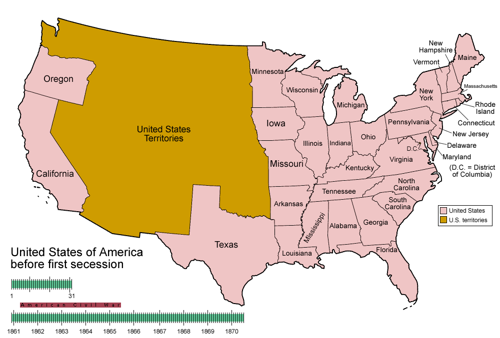
| Descripción | Animated map/timeline of the territorial evolution of the Confederate States of America, from first secession to end of Reconstruction. |
| Fecha | |
| Fuente | Trabajo propio |
| Autor | User:Golbez |
|
Licencia
Yo, titular de los derechos de autor de esta obra, la publico en los términos de las siguientes licencias:

|
Se autoriza la copia, distribución y modificación de este documento bajo los términos de la licencia de documentación libre GNU, versión 1.2 o cualquier otra que posteriormente publique la Fundación para el Software Libre; sin secciones invariables, textos de portada, ni textos de contraportada. Se incluye una copia de la dicha licencia en la sección titulada Licencia de Documentación Libre GNU. |
| Este archivo se encuentra bajo la licencia Creative Commons Genérica de Atribución/Compartir-Igual 3.0. | ||
| ||
| Esta etiqueta de licencia fue agregada a este archivo como parte de la actualización de la licencia GFDL. |
Este archivo se encuentra bajo la licencia Creative Commons de Atribución/Compartir-Igual 2.5 Genérica, 2.0 Genérica y 1.0 Genérica.
- Eres libre:
- de compartir – de copiar, distribuir y transmitir el trabajo
- de remezclar – de adaptar el trabajo
- Bajo las siguientes condiciones:
- atribución – Debes otorgar el crédito correspondiente, proporcionar un enlace a la licencia e indicar si realizaste algún cambio. Puedes hacerlo de cualquier manera razonable pero no de manera que sugiera que el licenciante te respalda a ti o al uso que hagas del trabajo.
- compartir igual – En caso de mezclar, transformar o modificar este trabajo, deberás distribuir el trabajo resultante bajo la misma licencia o una compatible como el original.
Puedes usar la licencia que prefieras.
Historial del archivo
Haz clic sobre una fecha y hora para ver el archivo tal como apareció en ese momento.
| Fecha y hora | Miniatura | Dimensiones | Usuario | Comentario | |
|---|---|---|---|---|---|
| actual | 05:30 5 jun 2014 | | 1000 × 677 (245 kB) | RedXIV | Removed incorrect information. Kentucky and Missouri never seceded. The state governments of Kentucky and Missouri never voted to secede. Claiming that their secession actually happened gives an inaccurate impression of the actual sequence of events. |
| 10:56 21 dic 2013 |  | 1000 × 677 (256 kB) | ChrisnHouston | I'm the one who broke the thumbnail. I'll try to fix it now... | |
| 13:38 20 dic 2013 |  | 1000 × 677 (1,75 MB) | Afernand74 | No image displayed. Reupload to try to solve the problem | |
| 11:33 7 nov 2013 |  | 1000 × 677 (1,75 MB) | ChrisnHouston | Adding a bar to the timeline to indicate when the actual fighting of the Civil War happened, which is one of the most important aspects of this map. | |
| 15:18 11 abr 2012 |  | 1000 × 677 (254 kB) | Golbez | rv - er, MO and KY were indeed admitted to the CSA, though it lacked any control over them. why not go to the talk page for the CSA on enwp and chat about my next version? | |
| 18:53 10 abr 2012 |  | 1000 × 677 (225 kB) | Travürsa | Fixed errors. | |
| 01:57 18 nov 2007 |  | 1000 × 677 (254 kB) | Golbez | Removing frame of WV counties; that was incorrect, they were always part of WV | |
| 09:54 4 mar 2007 |  | 1000 × 677 (259 kB) | Golbez | == Summary == {{Information |Description=Animated map/timeline of the territorial evolution of the Confederate States of America, from first secession to end of Reconstruction. |Source=Self-made. |Date=March 2007 |Author=User:Golbez |Permission= see b |
Usos del archivo
No hay páginas que enlacen a este archivo.
Uso global del archivo
Las wikis siguientes utilizan este archivo:
- Uso en af.wikipedia.org
- Uso en bcl.wikipedia.org
- Uso en cs.wikipedia.org
- Uso en da.wikipedia.org
- Uso en de.wikipedia.org
- Uso en en.wikipedia.org
- Confederate States of America
- Portal:United States/Selected picture
- User talk:-asx-
- User talk:Golbez/Archive 2
- Portal:Maps/Selected picture
- Wikipedia:Featured picture candidates/March-2007
- Wikipedia:Picture peer review/CSA evolution
- Wikipedia:Featured picture candidates/CSA states evolution.gif
- Wikipedia:Wikipedia Signpost/2007-03-20/Features and admins
- Wikipedia:Wikipedia Signpost/2007-03-20/SPV
- Portal:Maps/Selected picture/11
- Portal:United States/Selected picture/15
- Wikipedia:Featured picture candidates/November-2009
- Wikipedia:Featured picture candidates/Non-Native American Nations Control over N America 1750-2008.gif
- Wikipedia:Featured picture candidates/delist/2010
- Wikipedia:Featured picture candidates/delist/File:CSA states evolution.gif
- User:TheVirginiaHistorian/sandbox
- Wikipedia:Village pump (technical)/Archive 110
- Wikipedia:Wikipedia Signpost/Single/2007-03-20
- Uso en eo.wikipedia.org
- Uso en eu.wikipedia.org
- Uso en fr.wikipedia.org
- Uso en fr.wiktionary.org
- Uso en fy.wikipedia.org
- Uso en hr.wikipedia.org
- Uso en hu.wikipedia.org
- Uso en id.wikipedia.org
- Uso en ja.wikipedia.org
- Uso en la.wikipedia.org
- Uso en ms.wikipedia.org
- Uso en pt.wikipedia.org
- Uso en ro.wikipedia.org
- Uso en sr.wikipedia.org
- Uso en th.wikipedia.org
- Uso en tr.wikipedia.org
- Uso en uk.wikipedia.org