
Archivo:CampañaRumanaSeptiembreNoviembre1916Enero1917.svg

Tamaño de esta previsualización PNG del archivo SVG: 783 × 600 píxeles. Otras resoluciones: 313 × 240 píxeles · 627 × 480 píxeles · 1003 × 768 píxeles · 1280 × 980 píxeles · 2560 × 1961 píxeles · 2538 × 1944 píxeles.
Ver la imagen en su resolución original ((Imagen SVG, nominalmente 2538 × 1944 pixels, tamaño de archivo: 1,33 MB))
| Descripción |
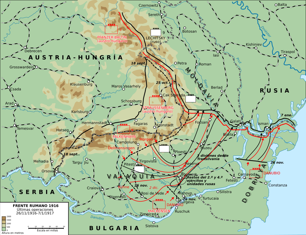
English: This map shows the conquest of Romania: November 1916 through till January of 1917
This map was created by the Department of Military Art and Engineering, at the U.S. Military Academy (West Point). The initial version was created under the supervision of General Vincent Esposito in 1959. It is now available on the West Point web site at: http://www.dean.usma.edu/history/web03/atlases/great%20war/great%20war%20%20pages/great%20war%20map%2037.htm
Español: Últimas operaciones de la campaña rumana de 1916: la retirada a Moldavia y la toma por los Imperios Centrales de Dobruja y Valaquia. |
||
| Fecha | (UTC) | ||
| Fuente | |||
| Autor |
|

| Esta es una imagen retocada, lo que significa que ha sido alterada digitalmente de su versión original. Modificaciones: turned into svg and Spanish. La original se puede ver aquí: Romania-WW1-3.jpg. Las modificaciones las hizo Rowanwindwhistler.
|
Este archivo se encuentra bajo la licencia Creative Commons Genérica de Atribución/Compartir-Igual 3.0.
- Eres libre:
- de compartir – de copiar, distribuir y transmitir el trabajo
- de remezclar – de adaptar el trabajo
- Bajo las siguientes condiciones:
- atribución – Debes otorgar el crédito correspondiente, proporcionar un enlace a la licencia e indicar si realizaste algún cambio. Puedes hacerlo de cualquier manera razonable pero no de manera que sugiera que el licenciante te respalda a ti o al uso que hagas del trabajo.
- compartir igual – En caso de mezclar, transformar o modificar este trabajo, deberás distribuir el trabajo resultante bajo la misma licencia o una compatible como el original.
Registro original de carga
This image is a derivative work of the following images:
- File:Romania-WW1-3.jpg licensed with PD-USGov
- 2006-12-28T16:42:16Z Electionworld 1018x868 (162492 Bytes) {{ew|en|Cglassey}} == Summary == This map shows the conquest of Romania: November 1916 through till January of 1917 This map was created by the Department of Military Art and Engineering, at the U.S. Military Academy (West P
Uploaded with derivativeFX
Historial del archivo
Haz clic sobre una fecha y hora para ver el archivo tal como apareció en ese momento.
| Fecha y hora | Miniatura | Dimensiones | Usuario | Comentario | |
|---|---|---|---|---|---|
| actual | 22:01 7 oct 2017 | | 2538 × 1944 (1,33 MB) | Rowanwindwhistler | Size |
| 21:51 7 oct 2017 |  | 2553 × 2000 (1,29 MB) | Rowanwindwhistler | Region names, river names, Jiu river, legend... | |
| 09:03 22 ene 2017 |  | 1284 × 983 (1,05 MB) | Rowanwindwhistler | Some minor errors corrected. Fake text added. | |
| 06:12 4 feb 2016 |  | 1204 × 922 (474 kB) | Rowanwindwhistler | Some text moved for better readability | |
| 06:05 4 feb 2016 |  | 1204 × 922 (474 kB) | Rowanwindwhistler | Minor corrections, some colours & symbols from https://en.wikipedia.org/wiki/Wikipedia:WikiProject_Maps/Conventions | |
| 15:36 8 sep 2010 |  | 1242 × 961 (464 kB) | Rowanwindwhistler | Wrong unit deleted | |
| 15:33 8 sep 2010 |  | 1242 × 961 (472 kB) | Rowanwindwhistler | {{Information |Description={{en|1=This map shows the conquest of Romania: November 1916 through till January of 1917 This map was created by the Department of Military Art and Engineering, at the U.S. Military Academy (West Point). The initial version was |
Usos del archivo
Las siguientes páginas usan este archivo:
Uso global del archivo
Las wikis siguientes utilizan este archivo:
- Uso en ca.wikipedia.org
- Uso en fr.wikipedia.org
- Uso en sh.wikipedia.org
- Uso en uk.wikipedia.org