
Archivo:Cliffe Roman Bridge 2.jpg
No se dispone de una resolución más alta.
Cliffe_Roman_Bridge_2.jpg (640 × 479 píxeles; tamaño de archivo: 125 kB; tipo MIME: image/jpeg)
Resumen
| Descripción |
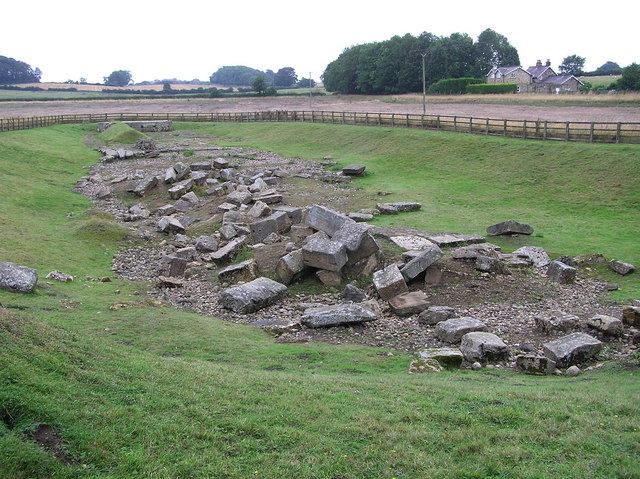
English: Source description says: "Roman Bridge : Piercebridge
On the south bank of the River Tees, an excavated site with the remains of abutments and piers. On the course of Dere Street Roman road." View across Tees from Cliffe, Richmondshire. This bridge was once part of the Roman road Dere Street, which is now diverted. |
| Fecha | |
| Fuente | https://www.geograph.org.uk/photo/221838 |
| Autor | Hugh Mortimer |
| Permiso (Reutilización de este archivo) |
© Copyright Hugh Mortimer and licensed for reuse under this Creative Commons Licence.Under the Creative Commons Licence, the image must be credited as specified by the contributor, an example of good wording is shown above. (The contributor of this photos is Hugh Mortimer).You should also mention that the photo is copyrighted but also licensed for further reuse. If you alter, transform, or build upon this work, you may distribute the resulting work only under a similar licence. |
| Posición de la cámara | | Ubicación de esta y otras imágenes en: OpenStreetMap |
|---|
_heading:202.00&language=es)
| Ubicación del objeto | | Ubicación de esta y otras imágenes en: OpenStreetMap |
|---|
_heading:202.00&language=es)
OSGB36: NZ 215 154 [100m precision] WGS84: 54:32.0054N 1:40.1558W
Licencia

|
Esta imagen proviene de la colección del proyecto Geograph British Isles. Veáse la página de esta fotografía en el sitio web de Geograph para más información del fotógrafo. El titular de los derechos de autor de esta imagen es Hugh Mortimer y autoriza utilizarla bajo la licencia Reconocimiento-CompartirIgual 2.0 de Creative Commons.
|
Este archivo se encuentra bajo la licencia Creative Commons Genérica de Atribución/Compartir-Igual 2.0.
Atribución: Hugh Mortimer
- Eres libre:
- de compartir – de copiar, distribuir y transmitir el trabajo
- de remezclar – de adaptar el trabajo
- Bajo las siguientes condiciones:
- atribución – Debes otorgar el crédito correspondiente, proporcionar un enlace a la licencia e indicar si realizaste algún cambio. Puedes hacerlo de cualquier manera razonable pero no de manera que sugiera que el licenciante te respalda a ti o al uso que hagas del trabajo.
- compartir igual – En caso de mezclar, transformar o modificar este trabajo, deberás distribuir el trabajo resultante bajo la misma licencia o una compatible como el original.
Historial del archivo
Haz clic sobre una fecha y hora para ver el archivo tal como apareció en ese momento.
| Fecha y hora | Miniatura | Dimensiones | Usuario | Comentario | |
|---|---|---|---|---|---|
| actual | 18:01 10 ene 2010 | | 640 × 479 (125 kB) | Storye book | == Summary == {{Information |Description={{en|1=Source description says: "Roman Bridge : Piercebridge On the south bank of the River Tees, an excavated site with the remains of abutments and piers. On the course of Dere Street Roman road." View across Tee |
Usos del archivo
La siguiente página usa este archivo:
Uso global del archivo
Las wikis siguientes utilizan este archivo:
- Uso en de.wikipedia.org
- Uso en en.wikipedia.org
- Uso en it.wikipedia.org