
Archivo:Courthouse Square as seen from Court Street Bridge, Owego, New York - 20220206.jpg

Tamaño de esta previsualización: 800 × 480 píxeles. Otras resoluciones: 320 × 192 píxeles · 1024 × 614 píxeles · 1280 × 768 píxeles · 2560 × 1536 píxeles · 3715 × 2229 píxeles.
Ver la imagen en su resolución original (3715 × 2229 píxeles; tamaño de archivo: 2,07 MB; tipo MIME: image/jpeg)
Resumen
| Descripción |
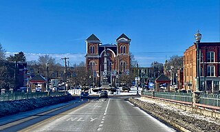
English: Courthouse Square in central Owego, New York, as seen from near the crest of the Court Street Bridge over the Susquehanna River on a February 2022 evening. The square has been the site of a public park dating back to 1797, only a few years after the village's incorporation, and it's today the central node of the historic downtown. In 1871, about half of the park was reclaimed by the municipal government to serve as the home of the Tioga County Courthouse, which was completed the following year to a design by locally-based architect Miles F. Howe and is seen at center in the photograph. Unusually for the Second Empire style, bluntly pointed arches are a recurring motif: you see them not only on the prominent limestone window heads above the double arched windows on the three-story towers that delineate the building's four corners, but also crowning the façade itself in the form of a raking cornice undergirded by block modillions. Even more unusual is the absence of a mansard roof, ordinarily the style's defining feature. The entrance, not visible from this perspective, is framed consecutively by a round arch of cut limestone and a shallow tetrastyle portico with stylized Corinthian pillars. The interior, too, is architecturally notable for its fine-quality woodwork, including chestnut wainscoting on the walls as well as window frames and furnishings in black walnut. In front rises the Tioga County Memorial, a 50-foot shaft of Barre granite crowned and flanked by depictions of Civil War soldiers and sailors, erected in 1890 to the memory of the local "heroes who fought, and martyrs who fell, that the Union might live". |
| Fecha | |
| Fuente | Trabajo propio |
| Autor | Andre Carrotflower |
| Posición de la cámara | | Ubicación de esta y otras imágenes en: OpenStreetMap |
|---|
Licencia
Yo, el titular de los derechos de autor de esta obra, la publico en los términos de la siguiente licencia:
Este archivo está disponible bajo la licencia Creative Commons Attribution-Share Alike 4.0 International.
- Eres libre:
- de compartir – de copiar, distribuir y transmitir el trabajo
- de remezclar – de adaptar el trabajo
- Bajo las siguientes condiciones:
- atribución – Debes otorgar el crédito correspondiente, proporcionar un enlace a la licencia e indicar si realizaste algún cambio. Puedes hacerlo de cualquier manera razonable pero no de manera que sugiera que el licenciante te respalda a ti o al uso que hagas del trabajo.
- compartir igual – En caso de mezclar, transformar o modificar este trabajo, deberás distribuir el trabajo resultante bajo la misma licencia o una compatible como el original.
Historial del archivo
Haz clic sobre una fecha y hora para ver el archivo tal como apareció en ese momento.
| Fecha y hora | Miniatura | Dimensiones | Usuario | Comentario | |
|---|---|---|---|---|---|
| actual | 02:33 14 feb 2022 | | 3715 × 2229 (2,07 MB) | Andre Carrotflower | Uploaded own work with UploadWizard |
Usos del archivo
La siguiente página usa este archivo:
Uso global del archivo
Las wikis siguientes utilizan este archivo:
- Uso en en.wikipedia.org
- Uso en sr.wikipedia.org