
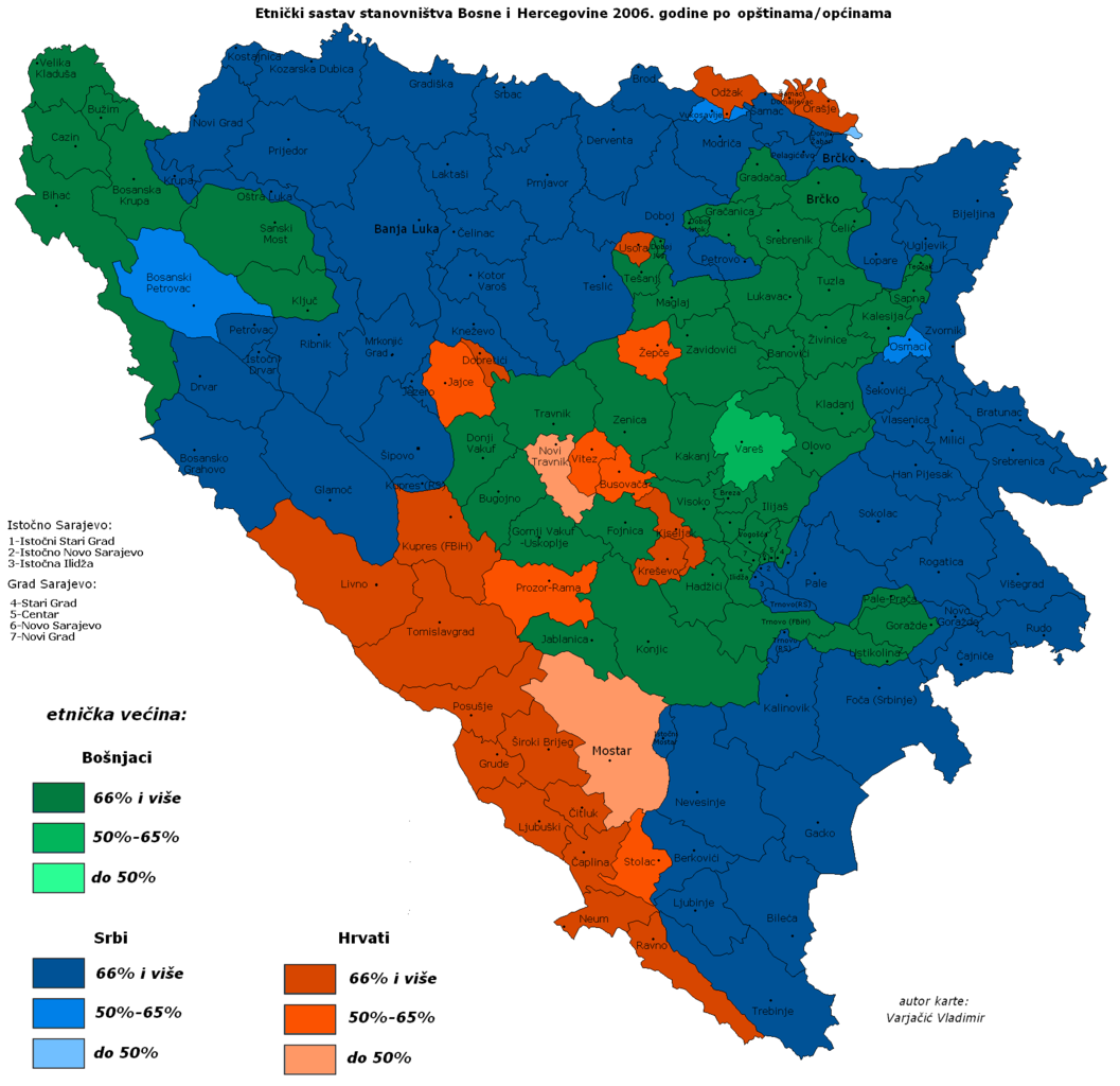
Archivo:DemoBIH2006.PNG

Tamaño de esta previsualización: 619 × 599 píxeles. Otras resoluciones: 248 × 240 píxeles · 496 × 480 píxeles · 793 × 768 píxeles · 1057 × 1024 píxeles · 1809 × 1752 píxeles.
Ver la imagen en su resolución original (1809 × 1752 píxeles; tamaño de archivo: 68 kB; tipo MIME: image/png)

Resumen
| Descripción |
|
||
| Fecha | |||
| Fuente | http://commons.wikimedia.org/wiki/ | ||
| Autor | Варја de Wikipedia en serbio (Vladimir Varjacic) | ||
| Otras versiones |
Obras derivadas de ésta: DemoBIH2006a.png:  BiHDemo2006.png:  |

Licencia

|
Se autoriza la copia, distribución y modificación de este documento bajo los términos de la licencia de documentación libre GNU, versión 1.2 o cualquier otra que posteriormente publique la Fundación para el Software Libre; sin secciones invariables, textos de portada, ni textos de contraportada. Se incluye una copia de la dicha licencia en la sección titulada Licencia de Documentación Libre GNU. |
| Este archivo se encuentra bajo la licencia Creative Commons Genérica de Atribución/Compartir-Igual 3.0. | ||
| Atribución: Vladimir Varjacic | ||
| ||
| Esta etiqueta de licencia fue agregada a este archivo como parte de la actualización de la licencia GFDL. |
Historial del archivo
Haz clic sobre una fecha y hora para ver el archivo tal como apareció en ese momento.
| Fecha y hora | Miniatura | Dimensiones | Usuario | Comentario | |
|---|---|---|---|---|---|
| actual | 14:57 10 jul 2015 | | 1809 × 1752 (68 kB) | Lilic | Reverted to version as of 08:40, 16 July 2007 |
| 08:40 16 jul 2007 |  | 1809 × 1752 (68 kB) | Nihad Hamzic | Greatly reduced image size by losslessly reducing color domain, and other optimisations. The image appearance is identical. | |
| 18:20 17 feb 2007 |  | 1809 × 1752 (212 kB) | Pokrajac | == Licensing == {{GFDL-no-disclaimers}} Category:Maps of the Federation of Bosnia and Herzegovina Category:Maps of Bosnia and Herzegovina | |
| 21:37 29 dic 2006 |  | 1809 × 1752 (211 kB) | Electionworld | {{ew|en|Estavisti}} == Summary == Taken from Serbian Wikipedia, the Republika Srpska article. It was created by a Serbian user based on various statistical data. There are some inaccuracies in the map (borders of Brčko district, etc.) == Licensing |
Usos del archivo
Las siguientes páginas usan este archivo:
Uso global del archivo
Las wikis siguientes utilizan este archivo:
- Uso en en.wikipedia.org