
Archivo:Europe 1783-1792 en.png

Tamaño de esta previsualización: 800 × 570 píxeles. Otras resoluciones: 320 × 228 píxeles · 640 × 456 píxeles · 1024 × 730 píxeles · 1280 × 913 píxeles · 2560 × 1825 píxeles · 3872 × 2761 píxeles.
Ver la imagen en su resolución original (3872 × 2761 píxeles; tamaño de archivo: 1,24 MB; tipo MIME: image/png)
_en.png)
.png)
.jpg)
Resumen
| Descripción |
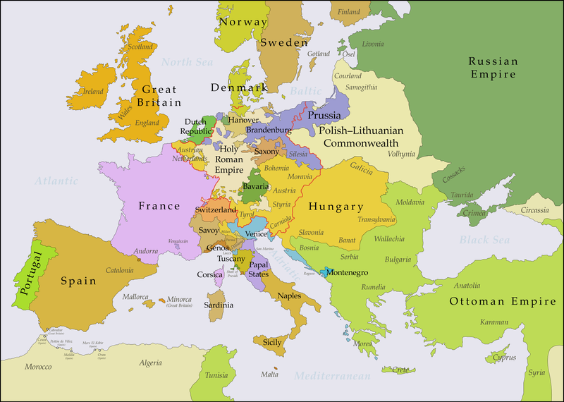
English: This map shows Europe in the years between the 1783 Russian annexation of Crimea after the Russo-Turkish War of 1768–1774 and the Russian annexation of Yedisan in 1792 at the end of the Russo-Turkish War of 1787–1792. The red line marks the borders of the Holy Roman Empire. The work was created with Inkscape and is mainly based on a map in: Putzger - Historischer Weltatlas, Berlin 1990, 78 pp. |
| Fecha | |
| Fuente | Trabajo propio, based on File:Europe 1748-1766 en.png |
| Autor | Bryan Rutherford |
Licencia
Yo, el titular de los derechos de autor de esta obra, la publico en los términos de la siguiente licencia:
Este archivo está disponible bajo la licencia Creative Commons Atribución-CompartirIgual 4.0 Internacional.
- Eres libre:
- de compartir – de copiar, distribuir y transmitir el trabajo
- de remezclar – de adaptar el trabajo
- Bajo las siguientes condiciones:
- atribución – Debes otorgar el crédito correspondiente, proporcionar un enlace a la licencia e indicar si realizaste algún cambio. Puedes hacerlo de cualquier manera razonable pero no de manera que sugiera que el licenciante te respalda a ti o al uso que hagas del trabajo.
- compartir igual – En caso de mezclar, transformar o modificar este trabajo, deberás distribuir el trabajo resultante bajo la misma licencia o una compatible como el original.
| Annotations | This image is annotated: View the annotations at Commons |
Historial del archivo
Haz clic sobre una fecha y hora para ver el archivo tal como apareció en ese momento.
| Fecha y hora | Miniatura | Dimensiones | Usuario | Comentario | |
|---|---|---|---|---|---|
| actual | 21:47 15 jul 2018 | | 3872 × 2761 (1,24 MB) | Bryanrutherford0 | Added the Ionian Islands, made the Duchy of Milan a Habsburg possession, gave Prussia control of Mansfeld (1780) |
| 02:29 10 jul 2018 |  | 3872 × 2761 (1,23 MB) | Bryanrutherford0 | Added Comtat Venaissin and redrew borders of Neuchâtel, Bishopric Basel, and Montbéliard | |
| 00:46 3 oct 2017 |  | 3872 × 2761 (1,23 MB) | Bryanrutherford0 | Transferred control of Saaremaa and Hiiumaa to Russia (1721 Treaty of Nystad), transferred control of Corsica to France (1769 [[:en:French conquest of Corsica|French conquest of... | |
| 15:03 30 sep 2017 |  | 3872 × 2761 (1,23 MB) | Bryanrutherford0 | Adjusted Russian-Swedish border in Finland to reflect Russian gains in the 1743 Treaty of Åbo after the Russo-Swedish War. | |
| 04:47 30 sep 2017 |  | 3872 × 2761 (1,23 MB) | Bryanrutherford0 | User created page with UploadWizard |
Usos del archivo
Las siguientes páginas usan este archivo:
Uso global del archivo
Las wikis siguientes utilizan este archivo:
- Uso en ar.wikipedia.org
- Uso en bg.wikipedia.org
- Uso en bn.wikipedia.org
- Uso en br.wikipedia.org
- Uso en ca.wikipedia.org
- Uso en el.wikipedia.org
- Uso en en.wikipedia.org
- Uso en fi.wikipedia.org
- Uso en fr.wikipedia.org
- Uso en it.wikipedia.org
- Uso en ja.wikipedia.org
- Uso en ka.wikipedia.org
- Uso en mk.wikipedia.org
- Uso en sl.wikipedia.org
- Uso en th.wikipedia.org
- Uso en tl.wikipedia.org
- Uso en uz.wikipedia.org
- Uso en vi.wikipedia.org
- Uso en zh.wikipedia.org