
Archivo:Herrera y Tordesillas Descripcion de las Yndias Ocidentales 1601 UTA.jpg

Tamaño de esta previsualización: 800 × 600 píxeles. Otras resoluciones: 320 × 240 píxeles · 640 × 480 píxeles · 1024 × 768 píxeles · 1280 × 960 píxeles · 2560 × 1919 píxeles · 4362 × 3270 píxeles.
Ver la imagen en su resolución original (4362 × 3270 píxeles; tamaño de archivo: 5,55 MB; tipo MIME: image/jpeg)
Resumen
| Título |
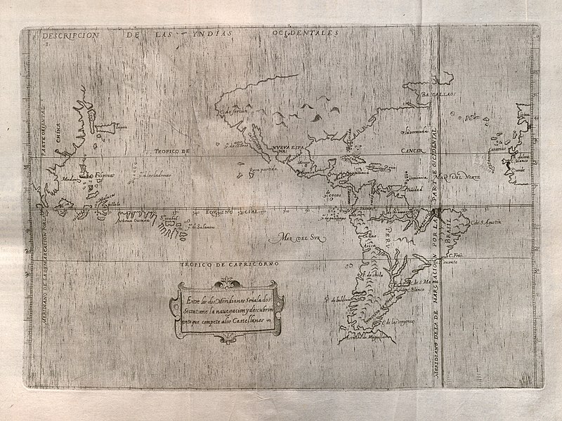
Español: Descripcion de las Yndias Ocidentales |
||||||||||||||||||||||||||
| Descripción |
English: Spain's official history of the discovery, conquest, and colonization of the Indies at the end of the sixteenth century includes maps of which this is the first, covering the western portions of the Iberian Peninsula and Africa, the Atlantic, both the Americas, the Pacific Ocean, and the eastern portion of Asia. Prominent at right in the map is the meridian line dividing Portuguese and Spanish possessions according to the 1494 Treaty of Tordesillas. The map is largely based upon manuscript charts by Juan Lopez de Velasco, created between ca. 1575-1580. By this time the Spanish had obviously accumulated considerable geographic knowledge along with their extensive claims to a large portion of the world. The outlines of the continents, islands, and various other geographical features are remarkably accurate for their time. |
||||||||||||||||||||||||||
| Fecha | |||||||||||||||||||||||||||
| Fuente | UTA Libraries Cartographic Connections: mapa / texto | ||||||||||||||||||||||||||
| Creador |
|
||||||||||||||||||||||||||
| Adquisición |
English: The University of Texas at Arlington Libraries Special Collections |
||||||||||||||||||||||||||
| Georeferencing | If inappropriate please set warp_status = skip to hide. | ||||||||||||||||||||||||||
| Bibliographic data | |||||||||||||||||||||||||||
| Publicación |
Historia General de los Hechos de los Castellanos en las Islas i Tierra Firme del Mar Oceano |
||||||||||||||||||||||||||
| Autor |
|
||||||||||||||||||||||||||
| Tomo | 2 | ||||||||||||||||||||||||||
| Lugar de publicación | Madrid | ||||||||||||||||||||||||||
| Editorial | |||||||||||||||||||||||||||
| Archival data | |||||||||||||||||||||||||||
| Colección |
|
||||||||||||||||||||||||||
| Dimensiones | altura: 22,5 cm; ancho: 32 cm | ||||||||||||||||||||||||||
| Técnica | grabado sobre papel | ||||||||||||||||||||||||||
| artwork-references | Burden, Philip D. (1996) The Mapping of North America: A List of Printed Maps 1511-1670, Herts, England: Raleigh Publications, nº140 , p. 169 | ||||||||||||||||||||||||||

Licencia

|
This file was provided to Wikimedia Commons by the University of Texas at Arlington Libraries as part of a cooperation project. The University of Texas at Arlington Libraries is part of the University of Texas at Arlington, a public research university located in Arlington, Texas.
|
|
Este material está en dominio público en los demás países donde el derecho de autor se extiende por 100 años (o menos) tras la muerte del autor. Esta obra está en el dominio público en los Estados Unidos porque fue publicada (o registrada con la Oficina del Derecho de Autor de los E.E. U.U.) antes del 1 de enero de 1929. | |
| Esta obra ha sido identificada como libre de las restricciones conocidas en virtud del derecho de autor, incluyendo todos los derechos conexos. | |
Historial del archivo
Haz clic sobre una fecha y hora para ver el archivo tal como apareció en ese momento.
| Fecha y hora | Miniatura | Dimensiones | Usuario | Comentario | |
|---|---|---|---|---|---|
| actual | 13:28 23 may 2019 | | 4362 × 3270 (5,55 MB) | Michael Barera | == {{int:filedesc}} == {{Map |title = ''Descripcion de las Yndias Ocidentales'' |description = {{en|Spain's official history of the discovery, conquest, and colonization of the Indies at the end of the sixteenth century includes maps of which this is the first, covering the western portions of the Iberian Peninsula and Africa, the Atlantic, both the Americas, the Pacific Ocean, and the eastern portion of Asia. Prominent at right in the map is the meridian line dividing Por... |
Usos del archivo
Las siguientes páginas usan este archivo:
Uso global del archivo
Las wikis siguientes utilizan este archivo:
- Uso en en.wikipedia.org
- Uso en lv.wikipedia.org