Archivo:Krahina e Gorës – (Gora region).svg

Contenido de la página no disponible en otros idiomas.
De Wikipedia, la enciclopedia libre

Ver la imagen en su resolución original((Imagen SVG, nominalmente 6436 × 6253 pixels, tamaño de archivo: 172 kB))

Resumen

Descripción
Shqip: Krahina e Gorës
English: Gora region
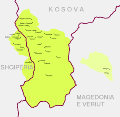
  • Map of Gorani settlements and Gora region (green) and adjacent area in the Polog region (yellow) that is culturally and linguistically associated with the core region.


Gorani inhabited settlements in Albania and Kosovo are synonymous with the geographical outline of Gora as a region. (see: Bardhoshi, Nebi (2016) "Small Numbers, Big issues: The Border areas as Social Arena of Legal Systems" in Exchange, Dialogue, New Divisions?: Ethnic Groups and Political Cultures in Eastern Europe, LIT Verlag, p. 83. ISBN: 9783643802095. )

  • Albania:

Steinke, Klaus (2010) Die slavischen Minderheiten in Albanien (SMA). 3. Gora, Múnich: Verlag Otto Sagner, p. 11. ISBN: 978-3-86688-112-9.

Schmidinger, Thomas (2013). Gora: Slawischsprachige Muslime zwischen Kosovo, Albanien, Mazedonien und Diaspora. Wiener Verlag. pp. 98-99. ISBN 9783944690049

  • Kosovo:

Schmidinger, Thomas (2013). Gora: Slawischsprachige Muslime zwischen Kosovo, Albanien, Mazedonien und Diaspora. Wiener Verlag. p. 65. ISBN 9783944690049

Schmidinger, Thomas (2018) "Forced return to empty villages: A case study of the Gorani in Kosovo" in Remigration to Post-Socialist Europe. Hopes and Realities of Return, Lit Verlag, p. 265. ISBN: 9783643910257.

  • North Macedonia (2 villages in the Polog region):

Koleva, Krasimira (2012) "Balkanisms today: The dialect of Župa (Kosovo)" in Balkanismen heute – Balkanisms today – Балканизмы сегодня, LIT Verlag, p. 351. ISBN: 9783643503886.

Rexhepi, Besnik; Mustafa, Behxhet; Hajdari, Avni; Rushidi-Rexhepi, Jehona; Quave, Cassandra L.; Pieroni, Andrea (2014). "Cross-cultural ethnobotany of the Sharr Mountains (northwestern Macedonia)". In Pieroni, Andrea; Quave, Cassandra L. (eds.). Ethnobotany and Biocultural Diversities in the Balkans. Springer. p. 70. ISBN 9781493914920


The boundaries of the region and its settlements shown in the map are based on the cadastral record. The following government based sources were used for the composition of the map.

  • Albania: Kukës County (map of Shishtavec unit [1]; map of Zapod unit [2])
  • Kosovo: Dragash Municipality covered in cadastral map [3]
  • North Macedonia: Bogovinje Municipality covered in cadastral map [4]
Fecha
Fuente Trabajo propio
Autor Resnjari

Licencia

Yo, el titular de los derechos de autor de esta obra, la publico en los términos de la siguiente licencia:
w:es:Creative Commons
atribución compartir igual
Este archivo está disponible bajo la licencia Creative Commons Attribution-Share Alike 4.0 International.
Eres libre:
  • de compartir – de copiar, distribuir y transmitir el trabajo
  • de remezclar – de adaptar el trabajo
Bajo las siguientes condiciones:
  • atribución – Debes otorgar el crédito correspondiente, proporcionar un enlace a la licencia e indicar si realizaste algún cambio. Puedes hacerlo de cualquier manera razonable pero no de manera que sugiera que el licenciante te respalda a ti o al uso que hagas del trabajo.
  • compartir igual – En caso de mezclar, transformar o modificar este trabajo, deberás distribuir el trabajo resultante bajo la misma licencia o una compatible como el original.

Leyendas

Añade una explicación corta acerca de lo que representa este archivo

Elementos representados en este archivo

representa a

Historial del archivo

Haz clic sobre una fecha y hora para ver el archivo tal como apareció en ese momento.

Fecha y horaMiniaturaDimensionesUsuarioComentario
actual10:57 7 sep 2020Miniatura de la versión del 10:57 7 sep 20206436 × 6253 (172 kB)ResnjariUploaded own work with UploadWizard

La siguiente página usa este archivo:

Uso global del archivo

Las wikis siguientes utilizan este archivo:

Metadatos