
Archivo:Kuwait-Iraq barrier.png

Ver la imagen en su resolución original (1060 × 1218 píxeles; tamaño de archivo: 964 kB; tipo MIME: image/png)
Transwiki approved by: w:en:User:Dmcdevit
This image was copied from wikipedia:en. The original description was:
Original map license (map from the CIA):
| Esta imagen se encuentra en el dominio público ya que su contenido proviene de un trabajo de la Agencia Central de Inteligencia de los Estados Unidos de América.
|

|
Source: Courtesy of the University of Texas Libraries, The University of Texas at Austin for the map originally found at : http://www.lib.utexas.edu/maps/middle_east_and_asia/kuwait_pol96.jpg
Modified map license (the one that can be seen here)
| Yo, el titular de los derechos de autor de esta obra, lo libero al dominio público. Esto aplica en todo el mundo. En algunos países esto puede no ser legalmente factible; si ello ocurriese: Concedo a cualquier persona el derecho de usar este trabajo para cualquier propósito, sin ningún tipo de condición al menos que éstas sean requeridas por la ley. |
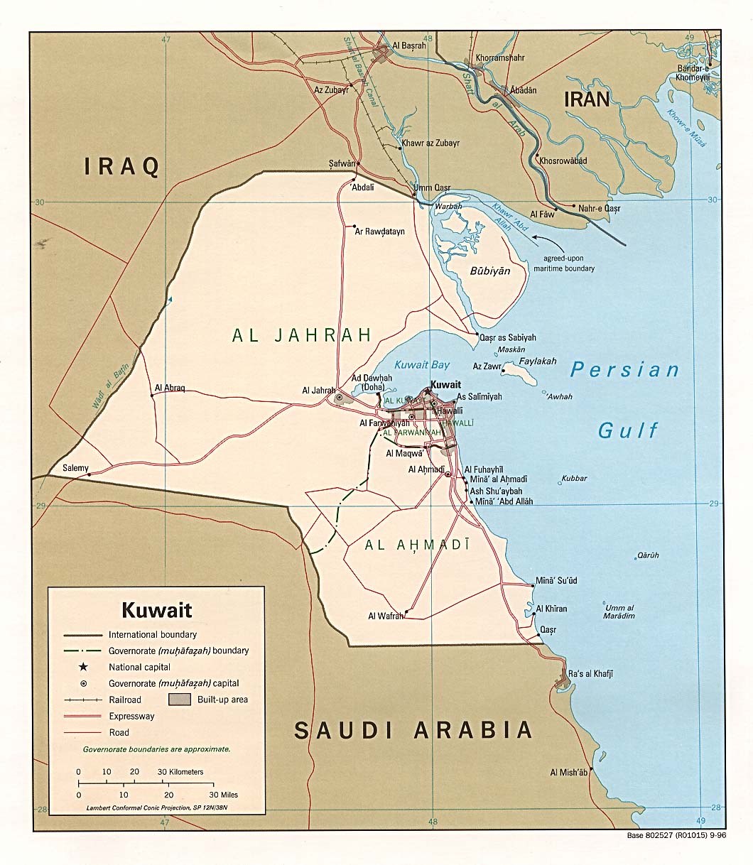
I drew the barrier on the map, based on the fact it extends 6 miles into Iraq and 3 into Kuwait.
Note
Even though this is a .png file the original file is .jpg, so the quality is fairly low.
.xcf version, can be opened in w:en:GIMP
Registro original de carga
| date/time | username | resolution | size | edit summary |
|---|---|---|---|---|
| 16:27, 21 June 2007 | w:en:User:Jackaranga | 1060×1218 | 1.38 MB | {{BadJPG}} ==Original map license (map from the CIA):== {{PD-USgov}} Source: ''Courtesy of the University of Texas Libraries, The University of Texas at Austin'' for the map originally found at : http://www.lib.utexas.edu/maps/middle_east_and_asia/kuwait |
Image description page history
| link | date/time | username | edit summary |
|---|---|---|---|
| http://en.wikipedia.org/w/index.php?title=Image:Kuwait-Iraq_barrier.png&redirect=no&oldid=139701165 | 08:50, 7 September 2007 | w:en:User:Dmcdevit | |
| http://en.wikipedia.org/w/index.php?title=Image:Kuwait-Iraq_barrier.png&redirect=no&oldid=139701165 | 16:52, 21 June 2007 | w:en:User:Jackaranga | |
| http://en.wikipedia.org/w/index.php?title=Image:Kuwait-Iraq_barrier.png&redirect=no&oldid=139696697 | 16:31, 21 June 2007 | w:en:User:Jackaranga | |
| http://en.wikipedia.org/w/index.php?title=Image:Kuwait-Iraq_barrier.png&redirect=no&oldid=139695842 | 16:27, 21 June 2007 | w:en:User:Jackaranga | ({{BadJPG}} ==Original map license (map from the CIA):== {{PD-USgov}} Source: ''Courtesy of the University of Texas Libraries, The University of Texas at Austin'' for the map originally found at : http://www.lib.utexas.edu/maps/middle_east_and_asia/kuwait) |
Historial del archivo
Haz clic sobre una fecha y hora para ver el archivo tal como apareció en ese momento.
| Fecha y hora | Miniatura | Dimensiones | Usuario | Comentario | |
|---|---|---|---|---|---|
| actual | 22:42 7 abr 2021 | | 1060 × 1218 (964 kB) | JohnVanVliet | jpg artifact removal |
| 04:51 8 sep 2007 |  | 1060 × 1218 (1,38 MB) | BetacommandBot | Transwiki approved by: w:en:User:Dmcdevit This image was copied from wikipedia:en. The original description was: {{BadJPG}} ==Original map license (map from the CIA):== {{PD-USGov-CIA}} Source: ''Courtesy of the University of Texas Libraries, The U |
Usos del archivo
La siguiente página usa este archivo:
Uso global del archivo
Las wikis siguientes utilizan este archivo:
- Uso en ar.wikipedia.org
- Uso en ca.wikipedia.org
- Uso en ckb.wikipedia.org
- Uso en de.wikipedia.org
- Uso en en.wikipedia.org
- Uso en fa.wikipedia.org
- Uso en fr.wikipedia.org
- Uso en id.wikipedia.org
- Uso en ja.wikipedia.org
- Uso en mzn.wikipedia.org
- Uso en nl.wikipedia.org
- Uso en pl.wikipedia.org
- Uso en pt.wikipedia.org
- Uso en tg.wikipedia.org
- Uso en uk.wikipedia.org
- Uso en www.wikidata.org
- Uso en zh.wikipedia.org