
Archivo:Map Denmark CIA extended.gif
No se dispone de una resolución más alta.
Map_Denmark_CIA_extended.gif (300 × 347 píxeles; tamaño de archivo: 16 kB; tipo MIME: image/gif)
Resumen
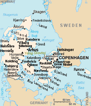
| Descripción | Map of Denmark, showing largest cities and island/region names. Most city names (31) have been labeled with font-face Arial or Arial Narrow, as font-size 8 or 10; the island/region names are labeled on the diagonal at a 20-degree slant. Denmark contains over 300 towns, but they are evenly dispersed around 35 main towns, except near Copenhagen, which has very high density. |
| Fecha | |
| Fuente | Derivative of CIA map (Wikimedia Commons): Image:Denmark-CIA WFB Map.png (adding 25 labels, restoring color to CIA hues, and magnified 15%) |
| Autor | Wikid77 (derivative of CIA map, adding 25 labels) |
| Otras versiones |
This map has some variations:
|
Licencia
Esta imagen se encuentra en el dominio público ya que su contenido proviene de CIA World Factbook, un trabajo de la Agencia Central de Inteligencia de los Estados Unidos de América.
|
 |
Format

This file is purposely maintained in GIF format (most international GIF-related patents have expired) for compatibility with the original CIA maps. Semi-automatic conversions to PNG-format might lose the color hues of the CIA maps, tending to shift to lighter blue and shift beige to white. A larger, detailed version of the map is being expanded, with more of the smaller 300 towns added.
Historial del archivo
Haz clic sobre una fecha y hora para ver el archivo tal como apareció en ese momento.
| Fecha y hora | Miniatura | Dimensiones | Usuario | Comentario | |
|---|---|---|---|---|---|
| actual | 16:26 30 nov 2012 | | 300 × 347 (16 kB) | Ras67 | cropped |
| 13:51 4 sep 2007 |  | 300 × 350 (16 kB) | Wikid77 | relabeled "NORWAY"/"POLAND"; raised "Taastrup"/"Koge" near city-dots | |
| 15:41 3 sep 2007 |  | 300 × 350 (16 kB) | Wikid77 | added "Kalundborg" by lowering "Fredericia"/"Odense"/"Fyn" and lowered Copenhagen star, "Taastrup"/"Koge" and "Greve Strand" etc. | |
| 13:24 31 ago 2007 |  | 300 × 350 (16 kB) | Wikid77 | slashed 'o' 3x | |
| 06:04 29 ago 2007 |  | 300 × 350 (16 kB) | Wikid77 | {{Information | Description=Map of Denmark, showing largest cities and island/region names. | Source=Derivative of CIA map | Date=29-August-2007 | Author= Wikid77 (derivative of CIA map) | Permission=(see below) }} |
Usos del archivo
La siguiente página usa este archivo:
Uso global del archivo
Las wikis siguientes utilizan este archivo:
- Uso en ast.wikipedia.org
- Uso en ca.wikipedia.org
- Uso en et.wikipedia.org
- Uso en fa.wikipedia.org
- Uso en gl.wikipedia.org
- Uso en hr.wikipedia.org
- Uso en ja.wikipedia.org
- Uso en kn.wikipedia.org
- Uso en ko.wikipedia.org
- Uso en mk.wikipedia.org
- Uso en ms.wikipedia.org
- Uso en pt.wikipedia.org
- Uso en th.wikipedia.org
- Uso en vi.wikipedia.org
- Uso en zh.wikipedia.org