
Archivo:Map of Eagle County, Colorado.png
Ver la imagen en su resolución original (3265 × 2571 píxeles; tamaño de archivo: 56 kB; tipo MIME: image/png)
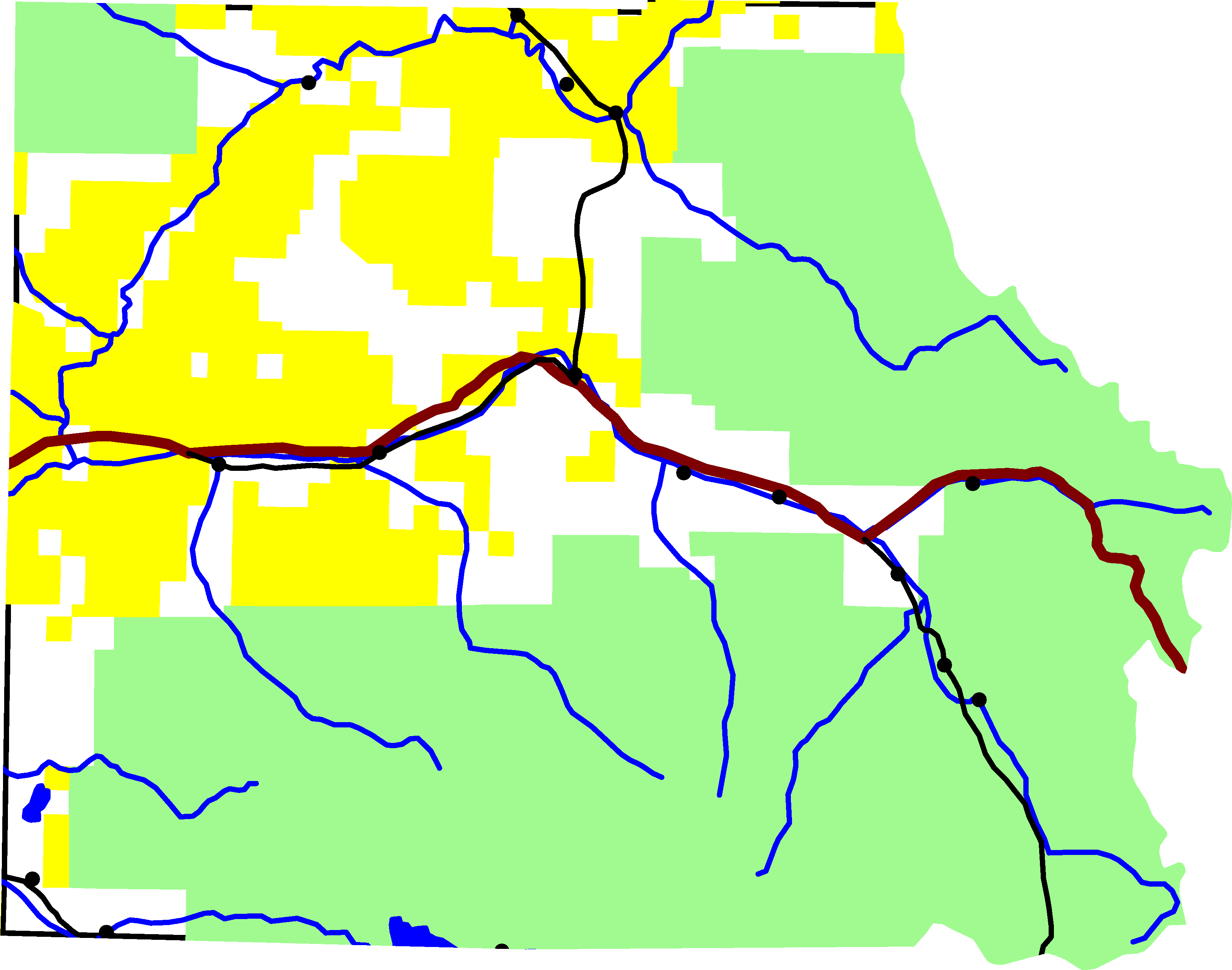
A map of Eagle County, Colorado. Green is White River National Forest, yellow is Bureau of Land Management land. The reddish line from east to west is Interstate 70. The black lines are roads. In the southeastern quadrant is U.S. Highway 24. In the north-central is Colorado State Highway 131. Running along I-70 is U.S. Highway 6. And in the south-west corner is Colorado State Highway 82.
For scale, the county is about 50 miles wide.
The lake on the southern border is Ruedi Reservior, with Fryingpan River. Gore Creek is the easternmost river on the map. It joins the Eagle River, which starts in the south-east corner of the county and flows north-west until it joins I-70. The river in the northern half of the county is the Colorado River.
David Benbennick made this map from data at nationalatlas.gov. The data is accurate to 0.000278 degrees, or about 65 feet.
| Yo, el titular de los derechos de autor de esta obra, lo libero al dominio público. Esto aplica en todo el mundo. En algunos países esto puede no ser legalmente factible; si ello ocurriese: Concedo a cualquier persona el derecho de usar este trabajo para cualquier propósito, sin ningún tipo de condición al menos que éstas sean requeridas por la ley. |
Historial del archivo
Haz clic sobre una fecha y hora para ver el archivo tal como apareció en ese momento.
| Fecha y hora | Miniatura | Dimensiones | Usuario | Comentario | |
|---|---|---|---|---|---|
| actual | 22:23 6 ago 2005 | | 3265 × 2571 (56 kB) | Dbenbenn | lighter green for national forest, #A0F090, taken from w:Wikipedia talk:WikiProject Maps |
| 16:01 2 ago 2005 |  | 3265 × 2571 (56 kB) | Dbenbenn | put county boundary underneath everything else. More accurate display at border. | |
| 16:15 1 ago 2005 |  | 3265 × 2571 (58 kB) | Dbenbenn | by me, PD |
Usos del archivo
La siguiente página usa este archivo:
Uso global del archivo
Las wikis siguientes utilizan este archivo:
- Uso en en.wikipedia.org
- Uso en ja.wikipedia.org
- Uso en ro.wikipedia.org