
Archivo:Map of Naqsh-e Rostam.jpg
No se dispone de una resolución más alta.
Map_of_Naqsh-e_Rostam.jpg (717 × 579 píxeles; tamaño de archivo: 179 kB; tipo MIME: image/jpeg)
Resumen
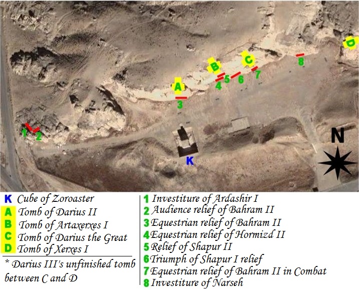
| Descripción | map of archeological site of Naqsh-e Rostam (Iran, fars Province, city of Marvdasht) |
| Fecha | |
| Fuente | Own work using NASA's satellite picture of the place and an artifact sheme according to belgium archeologist Louis Vanden Berghe. |
| Autor | Pentocelo |
| Otras versiones | with french legends Image:Map of Naqsh-e Rostam (fr).jpg |
.jpg)
Licencia
| Yo, el titular de los derechos de autor de esta obra, lo libero al dominio público. Esto aplica en todo el mundo. En algunos países esto puede no ser legalmente factible; si ello ocurriese: Concedo a cualquier persona el derecho de usar este trabajo para cualquier propósito, sin ningún tipo de condición al menos que éstas sean requeridas por la ley. |
Historial del archivo
Haz clic sobre una fecha y hora para ver el archivo tal como apareció en ese momento.
| Fecha y hora | Miniatura | Dimensiones | Usuario | Comentario | |
|---|---|---|---|---|---|
| actual | 04:56 27 feb 2011 | | 717 × 579 (179 kB) | Dr. Persi | I took this file from the original work done by the User Pentocelo. This is his original work and therefore the credit belongs to him. He however uploaded the file as no copyright, enabling me to improve his original version. He has created two versions o |
| 19:58 6 feb 2008 |  | 717 × 579 (75 kB) | Pentocelo~commonswiki | == Description == {{Information |Description= map of archeological site of Naqsh-e Rostam (Iran, fars Province, city of Marvdasht) |Source= Own work using NASA's satellite picture of the place and an artifact sheme according to belgium archeologist Louis | |
| 19:26 6 feb 2008 |  | 721 × 624 (83 kB) | Pentocelo~commonswiki | {{Information |Description= map of archeological site of Naqsh-e Rostam (Iran, fars Province, city of Marvdasht) |Source= Own work using NASA's satellite picture of the place and an artifact sheme according to belgium archeologist Louis Vanden Berghe. |Da |
Usos del archivo
Las siguientes páginas usan este archivo:
Uso global del archivo
Las wikis siguientes utilizan este archivo:
- Uso en ca.wikipedia.org
- Uso en de.wikivoyage.org
- Uso en en.wikipedia.org
- Uso en it.wikipedia.org
- Uso en sl.wikipedia.org
- Uso en vi.wikipedia.org