Archivo:Moss-above-bridge.jpg

Contenido de la página no disponible en otros idiomas.
De Wikipedia, la enciclopedia libre

Ver la imagen en su resolución original(2293 × 1485 píxeles; tamaño de archivo: 1,01 MB; tipo MIME: image/jpeg)

Resumen

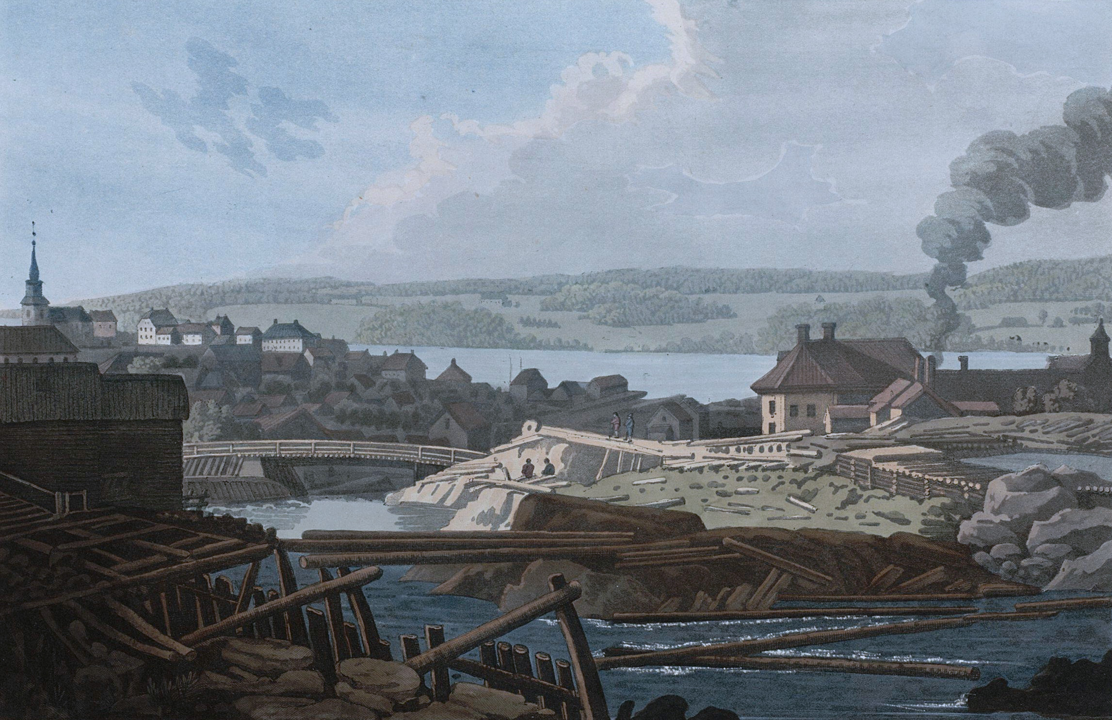
John William Edy: English: "Mos above the Bridge" Norsk bokmål: "Moss ovenfor Bryggen"   (Wikidata search (Cirrus search) Wikidata query (SPARQL)  Create new Wikidata item based on this file)
Artista
John William Edy  (1760–1820)  wikidata:Q3374273
 
Nombres alternativos
John William Edye; John William Edge; Edye; Edge; Edy
Descripción artista, grabador y pintor danés
Fecha de nacimiento/muerte 7 de mayo de 1760 Ver y modificar los datos en Wikidata 1820 Ver y modificar los datos en Wikidata
Lugar de nacimiento Dinamarca
Período de trabajo 1779 Ver y modificar los datos en Wikidata–1820 Ver y modificar los datos en Wikidata
Lugar de trabajo
Control de autoridades
artist QS:P170,Q3374273
Título
English: "Mos above the Bridge"
Norsk bokmål: "Moss ovenfor Bryggen"
Descripción
No. LXVII. MOS ABOVE THE BRIDGE.

At an elevated spot, on the ruins of an old saw-mill, this view of the town of Mos was taken ; where the waters of an extensive lake, called Van-Soe, enter it in a never-failing stream, down which vast quantities of timber are continually floating from the forests in the vicinity of the lakes above, to the booms about this place. Immediately under the bridge a quick descent occurs, forming a considerable and beautiful cascade. The water, by an ingenious arrangement of shutes or tanks formed of timber, is conducted from wheel to wheel through thirty saw-mills, the noise of which, with the roaring of the cascade, deafens the ear. The streams for the use of the furnace and forges, are carefully conducted in the wooden troughs, seen on the right, and are transmitted to them after turning a grist-mill, and passing through an aqueduct over the high road. The large house was one of the temporary residences of the late Honourable B. Anker ; beyond it is seen the smoke from his extensive iron-works, which occupy the whole space on that side down to the margin of the bay. Over the bridge, which is very compactly built of timber, for carriages with heavy loads, the road from Christiania joins the town of Mos. It is very amazing to look down from it, on the cascade, and on the numerous moving objects below, with the water roaring and foaming among them. There is a smaller bridge for foot passengers, half way down, near the house of an ingenious dyer, who has discovered that these waters possess the great requisite for producing and fixing the rich and brilliant scarlet colour on cloth, previously unknown in Norway. The specimens are equal to any in Europe. The principal street, commencing at the bridge, is inhabited chiefly by shopkeepers ; other streets branch off to the church, and toward the side of the bay. Mos, though not a large town, contains many good houses, particularly in the two quarters above-mentioned. The situation vies with any in Norway; the soil is productive ; the views in every point are interesting and pleasing ; the roads are good and of gentle ascent; provisions are abundant and reasonable ; and the inhabitants are frank and hospitable. The church is a large brick structure, with a lofty tower and spire ; it is handsomely decorated within, having a grand altar between two massy pillars. The devotional ceremonies of the Lutheran religion are performed here on Sundays, in a solemn and impressive manner, to a very numerous congregation, collected from miles around. Some of the natural beauties of the large peninsula of Ielon are seen over the bay, presenting the luxuriant appearance of the most studied park scenery, in ornamental villas, woods, groves, lawns, and cultivated grounds, as far as the eye can reach. The sandy isthmus, which forms the access to it by land, is immediately beyond the houses near the church ; it is elevated only a few feet above the level of the water, and is so narrow, that during certain strongwinds, the road over it is rendered almost impassable, being entirely overflowed by the surf of the sea below, or from the bay above.


Fecha 1800
date QS:P571,+1800-00-00T00:00:00Z/9
Fuente/fotógrafo Boydell's picturesque scenery of Norway, London, 1820. Plate no. 67 (p. 341 in scanned copy)
Otras versiones
Posición de la cámara59° 26′ 22″ N, 10° 40′ 09,98″ E Kartographer map based on OpenStreetMap.Ubicación de esta y otras imágenes en: OpenStreetMapinfo
La información geográfica de este archivo fue estimada retrospectivamente.
Por lo tanto, la ubicación puede ser algo imprecisa.
Se recomienda encarecidamente verificar y perfeccionar estas coordenadas.
This file is a digital replica of a document or a part of a document available at the National Library of Norway under the URN no-nb_digibok_2011072910001.

This tag does not indicate the copyright status of the attached work. A normal copyright tag is still required. See Commons:Licensing.


English | македонски | norsk bokmål | norsk nynorsk | norsk | +/−

Licencia

Esta es una reproducción fotográfica fiel de una obra de arte bidimensional de dominio público. La obra de arte misma se halla en el dominio público por el motivo siguiente:
Public domain

Este material está en dominio público en los demás países donde el derecho de autor se extiende por 100 años (o menos) tras la muerte del autor.


También debes incluir una etiqueta de dominio público de los Estados Unidos para indicar por qué esta obra está en el dominio público en los Estados Unidos.
La postura oficial de la Fundación Wikimedia considera que «las reproducciones fieles de obras de arte bidimensionales de dominio público forman parte del dominio público».
Esta reproducción fotográfica, por ende, también se considera de dominio público dentro de los Estados Unidos. Es posible que otras jurisdicciones restrinjan la reutilización de este contenido; consúltese Reutilización de fotografías PD-Art (en inglés) para más detalles.

Leyendas

Añade una explicación corta acerca de lo que representa este archivo

Elementos representados en este archivo

representa a

59°26'21.998"N, 10°40'9.984"E

Historial del archivo

Haz clic sobre una fecha y hora para ver el archivo tal como apareció en ese momento.

Fecha y horaMiniaturaDimensionesUsuarioComentario
actual19:24 23 feb 2012Miniatura de la versión del 19:24 23 feb 20122293 × 1485 (1,01 MB)DanmichaeloCooling the colours slightly, as the image was taken from a yellowish page
18:51 23 feb 2012Miniatura de la versión del 18:51 23 feb 20122293 × 1485 (1004 kB)Danmichaelofull resolution from scan, cropped
18:38 20 feb 2012Miniatura de la versión del 18:38 20 feb 2012661 × 545 (52 kB)Ulflarsen

La siguiente página usa este archivo:

Uso global del archivo

Metadatos