
Archivo:NorthSeaCurrents.png
Tamaño de esta previsualización: 458 × 599 píxeles. Otras resoluciones: 183 × 240 píxeles · 367 × 480 píxeles · 587 × 768 píxeles · 783 × 1024 píxeles · 1300 × 1700 píxeles.
Ver la imagen en su resolución original (1300 × 1700 píxeles; tamaño de archivo: 3,43 MB; tipo MIME: image/png)
Resumen
| Descripción |
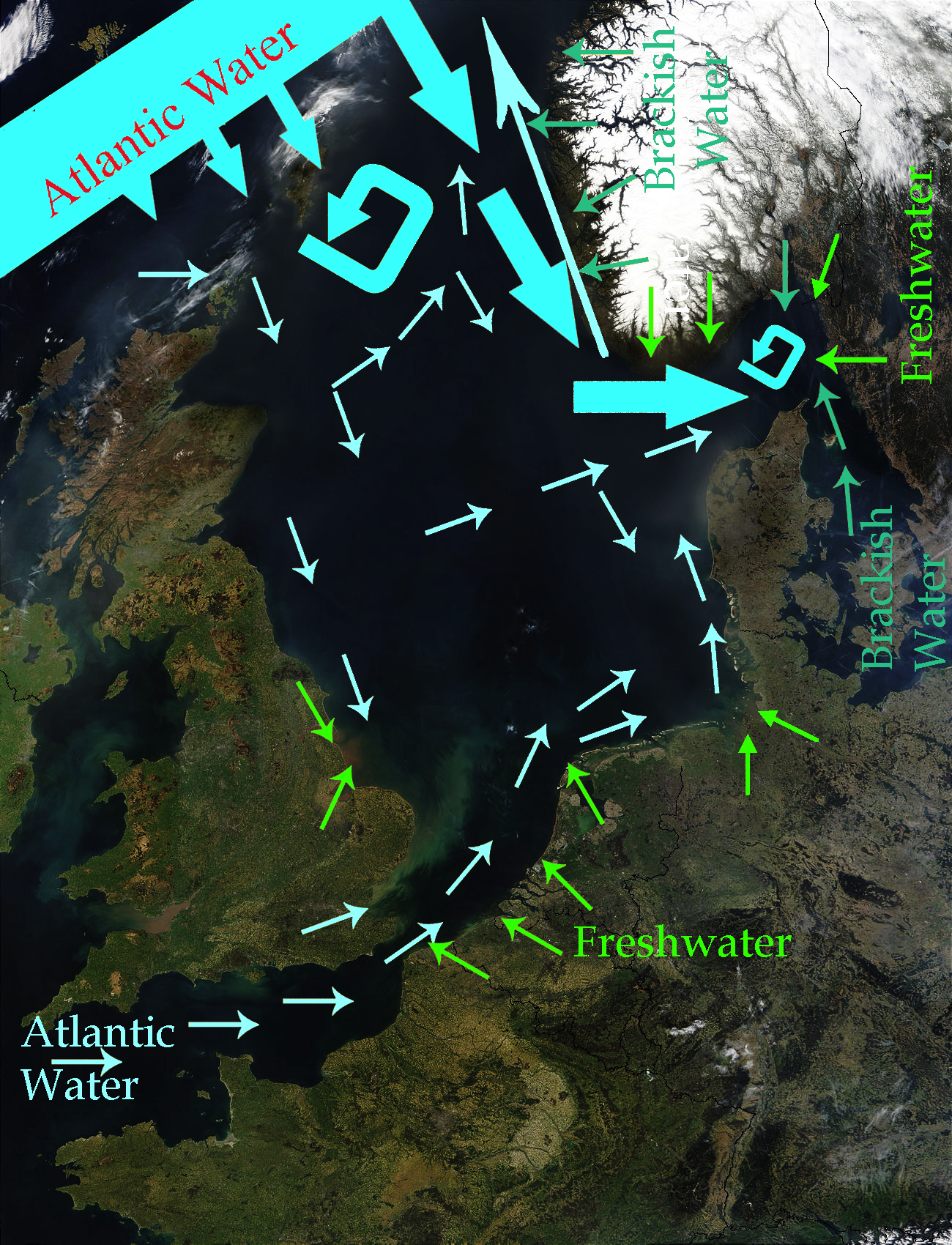
English: North Sea Map derived from NASA satellite image. This image depicts the currents in the North Sea. The intensive light blue broad arrows show the current and amount of flow from the Atlantic Ocean entering the northern area of the North Sea The smaller pale yellow arrows represent the current from the Atlantic Ocean entering through the English Channel. The bluish green arrows represent brackish water from fjords and the Baltic Sea. The green arrows represent freshwater from various rivers which drain land areas and discharge into the North Sea. Sources used to base this map upon were Safety at Sea currents and North Sea physiography (depth distribution and main currents) Guide to the Oceans By John Pernetta page 184 It would be nice to re-do this map with wiggly flowing arrows for the water currents. |
| Fecha | 2009-01-22, recoloured in 2014-04-27 |
| Fuente | Derivative work from File:NASA NorthSea1 2.jpg |
| Autor | SriMesh, recoloured by Ulamm (talk) 22:29, 27 April 2014 (UTC) |
| Otras versiones |
• File:North-Sea-Labels.jpg • NorthSeaCurrents,jpg, the original presentation of the currents |
Licencia
Yo, titular de los derechos de autor de esta obra, la publico en los términos de las siguientes licencias:
Este archivo se encuentra bajo la licencia Creative Commons Genérica de Atribución/Compartir-Igual 3.0.
- Eres libre:
- de compartir – de copiar, distribuir y transmitir el trabajo
- de remezclar – de adaptar el trabajo
- Bajo las siguientes condiciones:
- atribución – Debes otorgar el crédito correspondiente, proporcionar un enlace a la licencia e indicar si realizaste algún cambio. Puedes hacerlo de cualquier manera razonable pero no de manera que sugiera que el licenciante te respalda a ti o al uso que hagas del trabajo.
- compartir igual – En caso de mezclar, transformar o modificar este trabajo, deberás distribuir el trabajo resultante bajo la misma licencia o una compatible como el original.

|
Se autoriza la copia, distribución y modificación de este documento bajo los términos de la licencia de documentación libre GNU, versión 1.2 o cualquier otra que posteriormente publique la Fundación para el Software Libre; sin secciones invariables, textos de portada, ni textos de contraportada. Se incluye una copia de la dicha licencia en la sección titulada Licencia de Documentación Libre GNU. |
Puedes usar la licencia que prefieras.
Historial del archivo
Haz clic sobre una fecha y hora para ver el archivo tal como apareció en ese momento.
| Fecha y hora | Miniatura | Dimensiones | Usuario | Comentario | |
|---|---|---|---|---|---|
| actual | 22:56 27 abr 2014 | | 1300 × 1700 (3,43 MB) | Ulamm | once more |
| 22:48 27 abr 2014 |  | 1300 × 1700 (3,47 MB) | Ulamm | more freshwater arrows | |
| 22:29 27 abr 2014 |  | 1300 × 1700 (3,47 MB) | Ulamm | == {{int:filedesc}} == {{Information |Description={{en|1=''North Sea Map'' derived from NASA satellite image. This image depicts the currents in the North Sea. The dark yellow broad arrows show the current and amount of flow from the Atlantic Ocean en... |
Usos del archivo
La siguiente página usa este archivo:
Uso global del archivo
Las wikis siguientes utilizan este archivo:
- Uso en azb.wikipedia.org
- Uso en ca.wikipedia.org
- Uso en cs.wikipedia.org
- Uso en cy.wikipedia.org
- Uso en en.wikipedia.org
- Uso en fi.wikipedia.org
- Uso en hak.wikipedia.org
- Uso en hr.wikipedia.org
- Uso en vi.wikipedia.org