
Archivo:North East England counties 2009 map.svg

Tamaño de esta previsualización PNG del archivo SVG: 482 × 599 píxeles. Otras resoluciones: 193 × 240 píxeles · 386 × 480 píxeles · 618 × 768 píxeles · 824 × 1024 píxeles · 1647 × 2048 píxeles · 1082 × 1345 píxeles.
Ver la imagen en su resolución original ((Imagen SVG, nominalmente 1082 × 1345 pixels, tamaño de archivo: 723 kB))
Resumen
| Descripción |
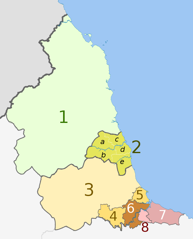
English: Map of the North East England region of England, showing its counties and administrative districts. The county colours are the same as those in File:English metropolitan and non-metropolitan counties 2009.svg.
Equirectangular map projection on WGS 84 datum, with N/S stretched 170% Geographic limits:
|
| Fecha | (UTC) |
| Fuente |
Este archivo deriva de: |
| Autor |
|
| Otras versiones |
 |


| Map | Ceremonial county | Unitary authority | Metropolitan districts |
|---|---|---|---|
 |
1. Northumberland | ||
| 2. Tyne and Wear metropolitan county |
a) Newcastle upon Tyne, b) Gateshead, c) North Tyneside, d) South Tyneside, e) Sunderland | ||
| Durham | 3. Durham | ||
| 4. Darlington | |||
| 5. Hartlepool | |||
| 6. Stockton-on-Tees | |||
| North Yorkshire (part only) | |||
| 7. Redcar and Cleveland | |||
| 8. Middlesbrough | |||
Licencia
Este archivo se encuentra bajo la licencia Creative Commons Genérica de Atribución/Compartir-Igual 3.0.
Atribución: Dr Greg and Nilfanion. Contains Ordnance Survey data © Crown copyright and database right 2011
- Eres libre:
- de compartir – de copiar, distribuir y transmitir el trabajo
- de remezclar – de adaptar el trabajo
- Bajo las siguientes condiciones:
- atribución – Debes otorgar el crédito correspondiente, proporcionar un enlace a la licencia e indicar si realizaste algún cambio. Puedes hacerlo de cualquier manera razonable pero no de manera que sugiera que el licenciante te respalda a ti o al uso que hagas del trabajo.
- compartir igual – En caso de mezclar, transformar o modificar este trabajo, deberás distribuir el trabajo resultante bajo la misma licencia o una compatible como el original.
Registro original de carga
This image is a derivative work of the following images:
- File:North_East_England__districts_2011_map.svg licensed with Cc-by-sa-3.0, GFDL
- 2011-05-01T18:56:43Z Nilfanion 1082x1345 (714062 Bytes) == Summary == {{Information |Description=Map of the [[w:North East England|North East England]] region showing the administrative districts. Equirectangular map projection on WGS 84 datum, with N/S stretched 170% Geographic
- File:English_ceremonial_counties_2010.svg licensed with Cc-by-sa-3.0, GFDL
- 2010-11-23T16:39:55Z Nilfanion 1108x1345 (308868 Bytes) thicker lines
- 2010-11-23T16:20:19Z Nilfanion 1108x1345 (301520 Bytes) tweaks
- 2010-10-26T20:34:20Z Nilfanion 817x990 (1391832 Bytes) {{Information |Description=Map showing the [[w:ceremonial counties of England]] including the City of London, in 2010. Equirectangular map projection on WGS 84 datum, with N/S stretched 170% Geographic limits: *West: 6.75W
Uploaded with derivativeFX
Historial del archivo
Haz clic sobre una fecha y hora para ver el archivo tal como apareció en ese momento.
| Fecha y hora | Miniatura | Dimensiones | Usuario | Comentario | |
|---|---|---|---|---|---|
| actual | 20:16 14 ago 2018 | | 1082 × 1345 (723 kB) | Inops | change letters labelling the boroughs of Tyne and Wearfrom white to black. Hardly intelligible when thumbnailed otherwise |
| 20:11 5 may 2012 |  | 1082 × 1345 (723 kB) | Dr Greg | lighten black boundary line | |
| 22:21 1 may 2012 |  | 1082 × 1345 (723 kB) | Dr Greg | == {{int:filedesc}} == {{Information |Description={{en|Map of the North East England region of England, showing its counties and administrative districts. The county colours are the same as those in [[:File:English metropolitan... |
Usos del archivo
La siguiente página usa este archivo:
Uso global del archivo
Las wikis siguientes utilizan este archivo:
- Uso en ar.wikipedia.org
- Uso en ca.wikipedia.org
- Uso en de.wikipedia.org
- Uso en en.wikipedia.org
- Uso en fa.wikipedia.org
- Uso en fr.wikipedia.org
- Uso en hu.wikipedia.org
- Uso en ja.wikipedia.org
- Uso en mr.wikipedia.org
- Uso en pl.wikipedia.org
- Uso en pnb.wikipedia.org
- Uso en th.wikipedia.org
- Uso en ur.wikipedia.org
- Uso en vi.wikipedia.org
- Uso en vls.wikipedia.org
- Uso en zh-yue.wikipedia.org