
Archivo:OCP07 Fig-6.jpg
No se dispone de una resolución más alta.
OCP07_Fig-6.jpg (600 × 473 píxeles; tamaño de archivo: 168 kB; tipo MIME: image/jpeg)
Resumen
| Descripción |
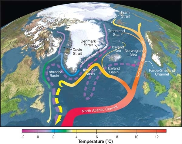
English: Topographic map of the Nordic Seas and subpolar basins with schematic circulation of surface currents (solid curves) and deep currents (dashed curves) that form a portion of the Atlantic meridional overturning circulation. Colors of curves indicate approximate temperatures. |
| Fecha | |
| Fuente | http://editors.eol.org/eoearth/wiki/File:OCP07_Fig-6.jpg |
| Autor | R. Curry, Woods Hole Oceanographic Institution/Science/USGCRP. |
Licencia
Este archivo se encuentra bajo la licencia Creative Commons Atribución 3.0 Unported.
- Eres libre:
- de compartir – de copiar, distribuir y transmitir el trabajo
- de remezclar – de adaptar el trabajo
- Bajo las siguientes condiciones:
- atribución – Debes otorgar el crédito correspondiente, proporcionar un enlace a la licencia e indicar si realizaste algún cambio. Puedes hacerlo de cualquier manera razonable pero no de manera que sugiera que el licenciante te respalda a ti o al uso que hagas del trabajo.
Historial del archivo
Haz clic sobre una fecha y hora para ver el archivo tal como apareció en ese momento.
| Fecha y hora | Miniatura | Dimensiones | Usuario | Comentario | |
|---|---|---|---|---|---|
| actual | 06:56 24 jul 2017 | | 600 × 473 (168 kB) | My name is not dave | User created page with UploadWizard |
Usos del archivo
La siguiente página usa este archivo:
Uso global del archivo
Las wikis siguientes utilizan este archivo:
- Uso en ca.wikipedia.org
- Uso en cs.wikipedia.org
- Uso en de.wiktionary.org
- Uso en en.wikipedia.org
- Uso en fr.wikipedia.org
- Uso en hr.wikipedia.org
- Uso en it.wikipedia.org
- Uso en pt.wikipedia.org
- Uso en zh.wikipedia.org