
Archivo:Opekiska Lock and Dam Monongahela.jpg

Tamaño de esta previsualización: 800 × 533 píxeles. Otras resoluciones: 320 × 213 píxeles · 640 × 427 píxeles · 1024 × 683 píxeles · 1500 × 1000 píxeles.
Ver la imagen en su resolución original (1500 × 1000 píxeles; tamaño de archivo: 329 kB; tipo MIME: image/jpeg)
| Descripción |
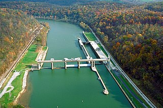
English: Opekiska Lock and Dam on the Monongahela River. The dam is located about seven miles northeast (downriver) from Fairmont, West Virginia, at river mile 115.4. The lock and dam were constructed 1961–64 by the U.S. Army Corps of Engineers to improve navigation on the Monongahela River, replacing 60-year-old locks 14 and 15. View is downriver to the northeast. |
|||
| Fecha | May 1, 1998 (as given on the descripton page, but the date is dubious) | |||
| Fuente |
U.S. Army Corps of Engineers Digital Visual Library Image page Image description page Digital Visual Library home page U.S. Army Corps of Engineers project page |
|||
| Autor | Margaret Luzier, U.S. Army Corps of Engineers | |||
| Permiso (Reutilización de este archivo) |
|
|||
| Localización | Fairmont, West Virginia, USA |
| Posición de la cámara | | Ubicación de esta y otras imágenes en: OpenStreetMap |
|---|
Historial del archivo
Haz clic sobre una fecha y hora para ver el archivo tal como apareció en ese momento.
| Fecha y hora | Miniatura | Dimensiones | Usuario | Comentario | |
|---|---|---|---|---|---|
| actual | 16:37 24 mar 2007 | | 1500 × 1000 (329 kB) | DanMS | {{Information | Description = {{en|Opekiska Lock and Dam on the Monongahela River. The dam is located about seven miles northeast (downriver) from Fairmont, West Virginia, at river mile 115.4. The lock and dam were constructed 1961–64 by the U.S. Arm |
Usos del archivo
La siguiente página usa este archivo:
Uso global del archivo
Las wikis siguientes utilizan este archivo:
- Uso en en.wikipedia.org
- Uso en fr.wikipedia.org
- Uso en gl.wikipedia.org
- Uso en it.wikipedia.org
- Uso en xmf.wikipedia.org