
Archivo:PIA19816-Mars-EstimatingCarbon-Orbiters-20150902.jpg

Ver la imagen en su resolución original (1234 × 616 píxeles; tamaño de archivo: 68 kB; tipo MIME: image/jpeg)
Resumen
| Descripción |
English: PIA19816: Multiple Instruments Used for Mars Carbon Estimate
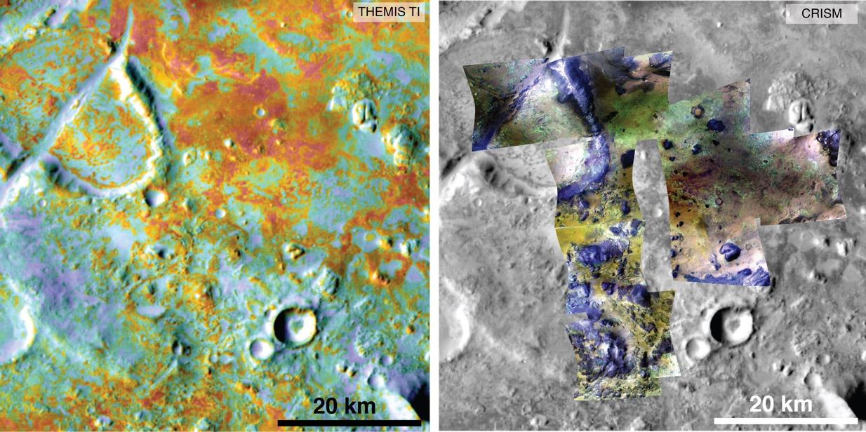
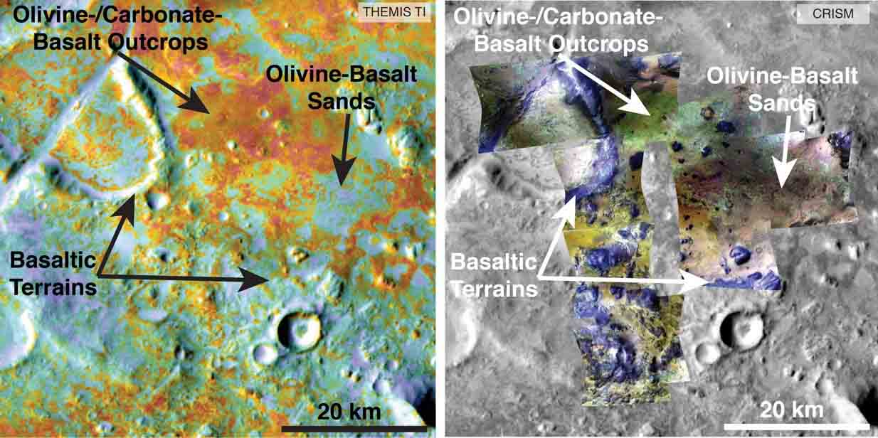
http://photojournal.jpl.nasa.gov/catalog/PIA19816 IMAGE: http://photojournal.jpl.nasa.gov/jpeg/PIA19816.jpg ANNOTATED IMAGE: http://photojournal.jpl.nasa.gov/figures/PIA19816_fig1.jpg Researchers estimating the amount of carbon held in the ground at the largest known carbonate-containing deposit on Mars utilized data from three different NASA Mars orbiters. Each image in this pair covers the same area about 36 miles (58 kilometers) wide in the Nili Fossae plains region of Mars' northern hemisphere. The tally of carbon content in the rocks of this region is a key piece in solving a puzzle of how the Martian atmosphere has changed over time. Carbon dioxide from the atmosphere on early Mars reacted with surface rocks to form carbonate, thinning the atmosphere. The image on the left presents data from the Thermal Emission Imaging System (THEMIS) instrument on NASA's Mars Odyssey orbiter. The color coding indicates thermal inertia -- the property of how quickly a surface material heats up or cools off. Sand, for example (blue hues), cools off quicker after sundown than bedrock (red hues) does. The color coding in the image on the right presents data from the Compact Reconnaissance Imaging Spectrometer for Mars (CRISM) instrument on NASA's Mars Reconnaissance Orbiter. From the brightness at many different wavelengths, CRISM data can indicate what minerals are present on the surface. In the color coding used here, green hues are consistent with carbonate-bearing materials, while brown or yellow hues are olivine-bearing sands and locations with purple hues are basaltic in composition. The gray scale base map is a mosaic of daytime THEMIS infrared images. Annotations point to areas with different surface compositions. The scale bar indicates 20 kilometers (12.4 miles). In addition to data from THEMIS and CRISM, researchers estimating the amount of carbon in rocks of the Nili Fossae plains used data from the Thermal Emission Spectrometer instrument on NASA's Mars Global Surveyor orbiter, which operated from 1997 to 2006, and from two telescopic cameras on Mars Reconnaissance Orbiter: the Context Camera and the High Resolution Imaging Science Experiment. Arizona State University, Tempe, provided and operates THEMIS. The Johns Hopkins University Applied Physics Laboratory, Laurel, Maryland, provided and operates CRISM. NASA's Jet Propulsion Laboratory, a division of the California Institute of Technology in Pasadena, manages the Mars Reconnaissance Orbiter and Mars Odyssey projects for NASA's Science Mission Directorate, Washington. Lockheed Martin Space Systems, Denver, built the orbiters and collaborates with JPL to operate them. |
| Fecha | |
| Fuente | http://photojournal.jpl.nasa.gov/figures/PIA19816_fig1.jpg |
| Autor | NASA/JPL-Caltech/ASU/JHUAPL |
Licencia
| Este archivo es de dominio público porque fue creado por la NASA. Las políticas sobre copyright de la NASA estipulan que «el material de la NASA no está protegido con copyright a menos que se indique lo contrario». (Políticas sobre copyright de la NASA o Políticas sobre la utilización de imágenes del Jet Propulsion Laboratory). | ||
 |
Advertencias:
|
Historial del archivo
Haz clic sobre una fecha y hora para ver el archivo tal como apareció en ese momento.
| Fecha y hora | Miniatura | Dimensiones | Usuario | Comentario | |
|---|---|---|---|---|---|
| actual | 23:19 2 sep 2015 | | 1234 × 616 (68 kB) | Drbogdan | User created page with UploadWizard |
Usos del archivo
Las siguientes páginas usan este archivo:
Uso global del archivo
Las wikis siguientes utilizan este archivo:
- Uso en ca.wikipedia.org
- Uso en en.wikipedia.org
- Uso en zh.wikipedia.org