
Archivo:PIA22546-Mars-AnnualCO2ice-N&SPoles-20180806.gif

Ver la imagen en su resolución original (849 × 423 píxeles; tamaño de archivo: 8,15 MB; tipo MIME: image/gif, bucleado, 36 frames, 5,4s)
Resumen
| Descripción |
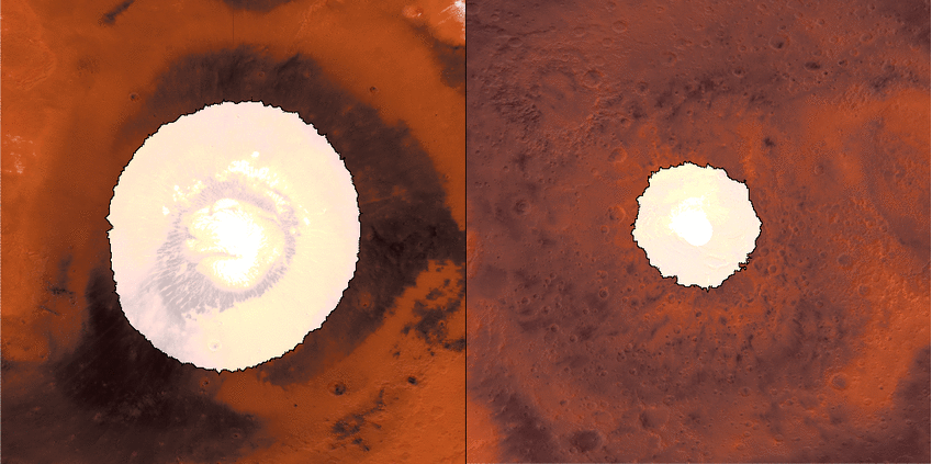
English: PIA22546: Growth and Retreat of the CO2 Ice at the Martian Poles
https://photojournal.jpl.nasa.gov/catalog/PIA22546 This animation shows a side-by-side comparison of CO2 ice at the north (left) and south (right) Martian poles over the course of a typical year (two Earth years). This simulation isn't based on photos; instead, the data used to create it came from two infrared instruments capable of studying the poles even when they're in complete darkness. As Mars enters fall and winter, reduced sunlight allows CO2 ice to grow, covering each pole. While ice at the north pole is fairly symmetrical, it's somewhat asymmetrical during its retreat from the south pole for reasons scientists still don't understand. Scientists are especially interested in studying how global dust events affect the growth and retreat of this polar ice. Mars' seasons are caused by a tilt in the planet, resulting in winter at one of the planet's poles while it's summer at the other. How do spacecraft observe the Martian surface in the polar night, when the Sun is below the horizon for weeks or even months, or in the spring, when it's hazy? They use infrared instruments measuring surface temperatures, even when the ground is in complete darkness or the atmosphere obscured. CO2 ice (sometimes called dry ice) is the coldest material found on Mars, and it is near -193 degrees Fahrenheit (-125 degrees Celsius), whereas ice free soil is generally warmer. As a result, scientists can track the position of the seasonal caps, even in the dark, using surface temperature measurements. Each panel of the animation is about 3,728 miles (6,000 kilometers) across. This data was collected by the Mars Climate Sounder (MCS) instrument on NASA's Mars Reconnaissance Orbiter, and the Thermal Emission Spectrometer (TES) onboard NASA's now defunct Mars Global Surveyor. The MCS data was collected between mid-2006 and the end of 2013; the TES data was collected between early 1999 to late 2006. |
| Fecha | |
| Fuente | https://photojournal.jpl.nasa.gov/archive/PIA22546.gif |
| Autor | NASA/JPL-Caltech |
Licencia
| Este archivo es de dominio público porque fue creado por la NASA. Las políticas sobre copyright de la NASA estipulan que «el material de la NASA no está protegido con copyright a menos que se indique lo contrario». (Políticas sobre copyright de la NASA o Políticas sobre la utilización de imágenes del Jet Propulsion Laboratory). | ||
 |
Advertencias:
|
Historial del archivo
Haz clic sobre una fecha y hora para ver el archivo tal como apareció en ese momento.
| Fecha y hora | Miniatura | Dimensiones | Usuario | Comentario | |
|---|---|---|---|---|---|
| actual | 19:35 6 ago 2018 | | 849 × 423 (8,15 MB) | Drbogdan | User created page with UploadWizard |
Usos del archivo
La siguiente página usa este archivo:
Uso global del archivo
Las wikis siguientes utilizan este archivo:
- Uso en ca.wikipedia.org
- Uso en en.wikipedia.org
- Uso en he.wikipedia.org