
Archivo:Piccadilly Station Manchester - geograph.org.uk - 692981.jpg
No se dispone de una resolución más alta.
Piccadilly_Station_Manchester_-_geograph.org.uk_-_692981.jpg (800 × 534 píxeles; tamaño de archivo: 100 kB; tipo MIME: image/jpeg)
Resumen
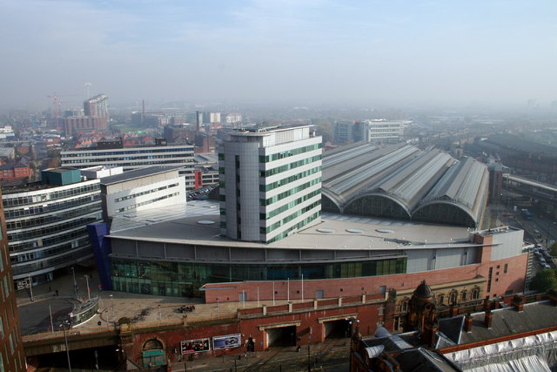
| Descripción |
English: Piccadilly Station Manchester Store Street Station opened in 1842 as the terminus of the Manchester and Birmingham Railway. As the rail network expanded it became London Road Station in 1849. It was rebuilt and became Manchester Piccadilly in 1960 for the new London Midland Region electric service to London. The two openings visible at the bottom centre of the photograph are for the Manchester Metrolink trams which went into service in 1992. The station was extensively modified for the 2002 Commonwealth Games. |
| Fecha | |
| Fuente | From geograph.org.uk |
| Autor | Peter Hyde |
| Atribución (requerido por la licencia) | Peter Hyde / Piccadilly Station Manchester / |
| Posición de la cámara | | Ubicación de esta y otras imágenes en: OpenStreetMap |
|---|
_heading:90.00&language=es)
| Ubicación del objeto | | Ubicación de esta y otras imágenes en: OpenStreetMap |
|---|
_heading:90.00&language=es)
Licencia

|
Esta imagen proviene de la colección del proyecto Geograph British Isles. Veáse la página de esta fotografía en el sitio web de Geograph para más información del fotógrafo. El titular de los derechos de autor de esta imagen es Peter Hyde y autoriza utilizarla bajo la licencia Reconocimiento-CompartirIgual 2.0 de Creative Commons.
|
Este archivo se encuentra bajo la licencia Creative Commons Genérica de Atribución/Compartir-Igual 2.0.
Atribución: Peter Hyde
- Eres libre:
- de compartir – de copiar, distribuir y transmitir el trabajo
- de remezclar – de adaptar el trabajo
- Bajo las siguientes condiciones:
- atribución – Debes otorgar el crédito correspondiente, proporcionar un enlace a la licencia e indicar si realizaste algún cambio. Puedes hacerlo de cualquier manera razonable pero no de manera que sugiera que el licenciante te respalda a ti o al uso que hagas del trabajo.
- compartir igual – En caso de mezclar, transformar o modificar este trabajo, deberás distribuir el trabajo resultante bajo la misma licencia o una compatible como el original.
Historial del archivo
Haz clic sobre una fecha y hora para ver el archivo tal como apareció en ese momento.
| Fecha y hora | Miniatura | Dimensiones | Usuario | Comentario | |
|---|---|---|---|---|---|
| actual | 14:41 17 abr 2014 | | 800 × 534 (100 kB) | G-13114 | resized |
| 05:44 8 feb 2011 |  | 640 × 427 (67 kB) | GeographBot | == {{int:filedesc}} == {{Information |description={{en|1=Piccadilly Station Manchester Store Street Station opened in 1842 as the terminus of the Manchester and Birmingham Railway. As the rail network expanded it became London Road Station in 1849. It was |
Usos del archivo
Las siguientes páginas usan este archivo:
Uso global del archivo
Las wikis siguientes utilizan este archivo:
- Uso en ar.wikipedia.org
- Uso en arz.wikipedia.org
- Uso en be-tarask.wikipedia.org
- Uso en cs.wikipedia.org
- Uso en de.wikipedia.org
- Uso en en.wikipedia.org
- Manchester
- North West England
- Manchester Piccadilly station
- Portal:North West England
- Transport in Manchester
- Architecture of Manchester
- List of busiest railway stations in Great Britain (2021–22)
- The Warehouse Project
- Manchester station group
- List of busiest railway stations in Great Britain (2020–21)
- List of busiest railway stations in Great Britain (2019–20)
- List of busiest railway stations in Great Britain
- Uso en fa.wikipedia.org
- Uso en fr.wikivoyage.org
- Uso en he.wikivoyage.org
- Uso en hu.wikipedia.org
- Uso en id.wikipedia.org
- Uso en it.wikivoyage.org
- Uso en ja.wikipedia.org
- Uso en nl.wikipedia.org
- Uso en www.wikidata.org
- Uso en yi.wikipedia.org
- Uso en zh.wikipedia.org