
Archivo:Ryknild street.jpg
No se dispone de una resolución más alta.
Ryknild_street.jpg (640 × 480 píxeles; tamaño de archivo: 175 kB; tipo MIME: image/jpeg)
| Descripción |
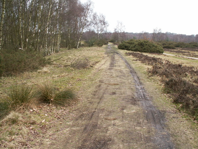
Ryknild Street Roman Road, Sutton Park. Ryknild Street Roman Road, Sutton Park Looking north east. The 1.5 mile section of the Roman road that runs through Sutton Park is one of the best preserved in the country, clearly showing the constructional features typical of roads in this part of the empire. This section of road linked the forts at Metcley (Birmingham) and Wall near Lichfield. |
| Fecha | |
| Fuente | From geograph.org.uk |
| Autor | Phil Champion |
| Permiso (Reutilización de este archivo) |
Creative Commons Attribution Share-alike license 2.0 |
| Posición de la cámara | | Ubicación de esta y otras imágenes en: OpenStreetMap |
|---|

|
Esta imagen proviene de la colección del proyecto Geograph British Isles. Veáse la página de esta fotografía en el sitio web de Geograph para más información del fotógrafo. El titular de los derechos de autor de esta imagen es Phil Champion y autoriza utilizarla bajo la licencia Reconocimiento-CompartirIgual 2.0 de Creative Commons.
|
Este archivo se encuentra bajo la licencia Creative Commons Genérica de Atribución/Compartir-Igual 2.0.
Atribución: Phil Champion
- Eres libre:
- de compartir – de copiar, distribuir y transmitir el trabajo
- de remezclar – de adaptar el trabajo
- Bajo las siguientes condiciones:
- atribución – Debes otorgar el crédito correspondiente, proporcionar un enlace a la licencia e indicar si realizaste algún cambio. Puedes hacerlo de cualquier manera razonable pero no de manera que sugiera que el licenciante te respalda a ti o al uso que hagas del trabajo.
- compartir igual – En caso de mezclar, transformar o modificar este trabajo, deberás distribuir el trabajo resultante bajo la misma licencia o una compatible como el original.
Historial del archivo
Haz clic sobre una fecha y hora para ver el archivo tal como apareció en ese momento.
| Fecha y hora | Miniatura | Dimensiones | Usuario | Comentario | |
|---|---|---|---|---|---|
| actual | 13:53 31 dic 2008 | | 640 × 480 (175 kB) | Victuallers | {{Information |Description=Ryknild Street Roman Road, Sutton Park. Ryknild Street Roman Road, Sutton Park Looking north east. The 1.5 mile section of the Roman road that runs through Sutton Park is one of the best preserved in the co |
Usos del archivo
La siguiente página usa este archivo:
Uso global del archivo
Las wikis siguientes utilizan este archivo:
- Uso en be-tarask.wikipedia.org
- Uso en ca.wikipedia.org
- Uso en cs.wikipedia.org
- Uso en en.wikipedia.org
- Uso en fi.wikipedia.org
- Uso en fr.wikipedia.org
- Uso en it.wikipedia.org
- Uso en la.wikipedia.org
- Uso en no.wikipedia.org
- Uso en pt.wikipedia.org
- Uso en ru.wikipedia.org
- Uso en simple.wikipedia.org
- Uso en www.wikidata.org