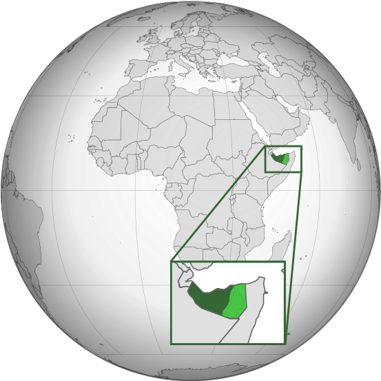
Archivo:Somaliland (orthographic projection).svg
Apariencia

Tamaño de esta previsualización PNG del archivo SVG: 553 × 553 píxeles. Otras resoluciones: 240 × 240 píxeles · 480 × 480 píxeles · 768 × 768 píxeles · 1024 × 1024 píxeles · 2048 × 2048 píxeles.
Ver la imagen en su resolución original ((Imagen SVG, nominalmente 553 × 553 pixels, tamaño de archivo: 274 kB))
Historial del archivo
Haz clic sobre una fecha y hora para ver el archivo tal como apareció en ese momento.
| Fecha y hora | Miniatura | Dimensiones | Usuario | Comentario | |
|---|---|---|---|---|---|
| actual | 09:17 28 mar 2024 |  | 553 × 553 (274 kB) | Alaexis | I believe that this version is better; it simply marks the disputed area without saying who controls it; see these articles with similar maps https://www.economist.com/middle-east-and-africa/2021/05/06/somaliland-an-unrecognised-state-is-winning-friends-abroad https://www.thehindu.com/news/international/ethiopia-breakaway-somaliland-sign-port-deal-somalias-cabinet-calls-emergency-meet/article67697822.ece |
| 18:49 20 ene 2024 |  | 553 × 553 (250 kB) | Buufin | Reverted to version as of 23:17, 1 October 2023 (UTC)Vandalism | |
| 07:37 20 ene 2024 |  | 553 × 553 (274 kB) | QalasQalas | Reverted to version as of 14:53, 27 September 2023 (UTC) | |
| 23:17 1 oct 2023 |  | 553 × 553 (250 kB) | Subayerboombastic | I believe it is premature to label all of the territory now claimed by Khatumo as being uncontrolled by Somaliland. It is notoriously difficult to get a clear picture of the the facts on the ground for this conflict. All that is known for sure is that Somaliland forces were pushed out of Las Anod and are currently stationed in Oog. It is unclear if Khatumo forces have managed affect control over towns in the region such as Hudan or Taleh or if Somaliland's governmental structure is still in p... | |
| 04:09 29 sep 2023 |  | 553 × 553 (277 kB) | Billboardbillal | Subayerboombastic deleted my upload without explanation and without an edit summary | |
| 03:50 29 sep 2023 |  | 553 × 553 (250 kB) | Subayerboombastic | Reverted to version as of 16:59, 28 September 2023 (UTC) | |
| 18:33 28 sep 2023 |  | 553 × 553 (277 kB) | Billboardbillal | shaded west Xudun and Erigabo district and Aynabo up to Oog as Somaliland controlled | |
| 16:59 28 sep 2023 |  | 553 × 553 (250 kB) | Seepsimon | Reverted to version as of 05:21, 27 September 2023 (UTC) both caynaba and western xudun and South western ceerigabo is controlled by Somaliland. Go to Google map and see how caynaba and buhoodle are shaded each other. You have to make accurate map other wise stop the vandalizing. | |
| 14:53 27 sep 2023 |  | 553 × 553 (274 kB) | Billboardbillal | updated whilst removing Aynabo according to Seepsimon suggestion | |
| 05:21 27 sep 2023 |  | 553 × 553 (250 kB) | Seepsimon | Reverted to version as of 14:12, 10 May 2021 (UTC) Your map isn't accurate. You added caynaba district of sool isn't controlled by Somaliland and that is inaccurate. Caynaba is the northern of buhodle district |
Usos del archivo
Las siguientes páginas usan este archivo:
Uso global del archivo
Las wikis siguientes utilizan este archivo:
- Uso en af.wikipedia.org
- Uso en am.wikipedia.org
- Uso en ang.wikipedia.org
- Uso en ar.wikipedia.org
- Uso en arz.wikipedia.org
- Uso en ast.wikipedia.org
- Uso en azb.wikipedia.org
- Uso en az.wikipedia.org
- Uso en bg.wikipedia.org
- Uso en bs.wikipedia.org
- Uso en ca.wikipedia.org
- Uso en cdo.wikipedia.org
- Uso en ce.wikipedia.org
- Uso en cs.wikipedia.org
- Uso en da.wikipedia.org
- Uso en diq.wikipedia.org
- Uso en el.wikipedia.org
- Uso en en.wikipedia.org
- Somaliland
- List of sovereign states and dependent territories in the Indian Ocean
- Outline of Somaliland
- LGBT rights in Somaliland
- Wikipedia:WikiProject Somaliland
- Portal:Somaliland
- Talk:Somaliland/Archive 2
- Portal:Somaliland/Intro
- Wikipedia:Graphics Lab/Map workshop/Archive/2016
- List of conflicts in Somaliland
- Uso en en.wikinews.org
- Uso en en.wikivoyage.org
- Uso en et.wikipedia.org
- Uso en fa.wikipedia.org
- Uso en fi.wikipedia.org
- Uso en fr.wikipedia.org
- Uso en fr.wiktionary.org
- Uso en ga.wikipedia.org
- Uso en gcr.wikipedia.org
- Uso en gl.wikipedia.org
- Uso en hak.wikipedia.org
- Uso en ha.wikipedia.org
- Uso en he.wikipedia.org
- Uso en hi.wikipedia.org
- Uso en hu.wikipedia.org
- Uso en hy.wikipedia.org
- Uso en id.wikipedia.org
- Uso en incubator.wikimedia.org
- Uso en is.wikipedia.org
- Uso en it.wikipedia.org
Ver más uso global de este archivo.
