
Archivo:South Africa 2011 population density map.svg

Tamaño de esta previsualización PNG del archivo SVG: 684 × 599 píxeles. Otras resoluciones: 274 × 240 píxeles · 548 × 480 píxeles · 876 × 768 píxeles · 1168 × 1024 píxeles · 2337 × 2048 píxeles · 809 × 709 píxeles.
Ver la imagen en su resolución original ((Imagen SVG, nominalmente 809 × 709 pixels, tamaño de archivo: 1,93 MB))
Resumen
| Descripción |
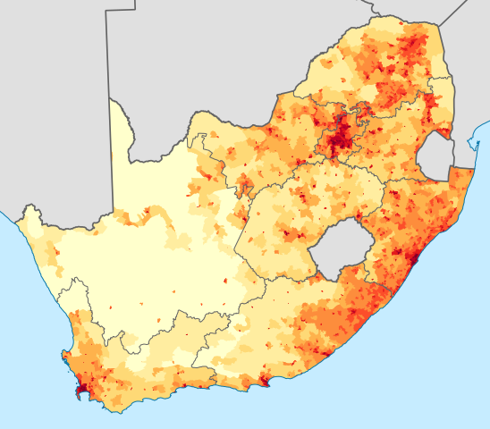
English: Population density map of South Africa, based on the 2011 census using ward-level data.
<1 inhabitant/km²
1–3 inhabitants/km²
3–10 inhabitants/km²
10–30 inhabitants/km²
30–100 inhabitants/km²
100–300 inhabitants/km²
300–1000 inhabitants/km²
1000–3000 inhabitants/km²
>3000 inhabitants/km²
Projection is Albers Equal-Area Conic, with standard parallels at 25.5° S and 31.5° S, and origin at 28.5° S 24.5° E.Deutsch: Bevölkerungsdichte Südafrikas im Jahr 2011:
<1 Einwohner/km²
1–3 Einwohner/km²
3–10 Einwohner/km²
10–30 Einwohner/km²
30–100 Einwohner/km²
100–300 Einwohner/km²
300–1000 Einwohner/km²
1000–3000 Einwohner/km²
>3000 Einwohner/km² |
| Fecha | |
| Fuente | Statistics South Africa's Census 2011 is the source of the basic population data. The map results from my own processing of the data. For ward boundaries see File:South Africa electoral wards 2011 blank.svg. |
| Autor | Htonl |
| Otras versiones |
South Africa 2011 population density map (hex cells).svg: .svg) |
Licencia
The following license applies to the population data on which the map is based:

|
El propietario de los derechos de autor de este archivo, Stats SA, autoriza a cualquier persona a usarlo para cualquier propósito, siempre que el titular de los derechos de autor sea atribuido apropiadamente. La redistribución, la realización de trabajos derivados, el uso comercial y otro tipo de usos están permitidos. |
Atribución:
"the user acknowledges Stats SA as the source of the basic data wherever they process, apply, utilise, publish or distribute the data, and also that they specify that the relevant application and analysis (where applicable) result from their own processing of the data" [1]
|
The following tag applies to the map itself:
| Yo, el titular de los derechos de autor de esta obra, lo libero al dominio público. Esto aplica en todo el mundo. En algunos países esto puede no ser legalmente factible; si ello ocurriese: Concedo a cualquier persona el derecho de usar este trabajo para cualquier propósito, sin ningún tipo de condición al menos que éstas sean requeridas por la ley. |
Historial del archivo
Haz clic sobre una fecha y hora para ver el archivo tal como apareció en ese momento.
| Fecha y hora | Miniatura | Dimensiones | Usuario | Comentario | |
|---|---|---|---|---|---|
| actual | 23:36 14 nov 2012 | | 809 × 709 (1,93 MB) | Htonl | fix KZN coast error |
| 21:57 14 nov 2012 |  | 809 × 709 (1,93 MB) | Htonl | == {{int:filedesc}} == {{Information |Description={{en|1=Population density map of South Africa, based on the 2011 census using ward-level data. {{legend|#ffffcc|<1 inhabitant/km²}} {{legend|#ffeda0|1–3 inhabitants/km²}} {{legend|#fed976|3–10 ... |
Usos del archivo
Las siguientes páginas usan este archivo:
Uso global del archivo
Las wikis siguientes utilizan este archivo:
- Uso en af.wikipedia.org
- Uso en azb.wikipedia.org
- Uso en az.wikipedia.org
- Uso en ca.wikipedia.org
- Uso en cs.wikipedia.org
- Uso en de.wikipedia.org
- Uso en el.wikipedia.org
- Uso en en.wikipedia.org
- Uso en et.wikipedia.org
- Uso en fr.wikipedia.org
- Uso en gl.wikipedia.org
- Uso en he.wikipedia.org
- Uso en hu.wikipedia.org
- Uso en hy.wikipedia.org
- Uso en ja.wikipedia.org
- Uso en ka.wikipedia.org
- Uso en ko.wikipedia.org
- Uso en la.wikipedia.org
- Uso en lt.wikipedia.org
- Uso en ml.wikipedia.org
- Uso en nl.wikipedia.org
- Uso en no.wikipedia.org
- Uso en pt.wikipedia.org
- Uso en ro.wikipedia.org
- Uso en ru.wikipedia.org
- Uso en sr.wikipedia.org
- Uso en sv.wikipedia.org
- Uso en te.wikipedia.org
- Uso en tg.wikipedia.org
- Uso en tr.wikipedia.org
- Uso en uk.wikipedia.org
- Uso en zh.wikipedia.org