
Archivo:The Big Muddy, Western Edition (6987590721).jpg

Ver la imagen en su resolución original (5559 × 3706 píxeles; tamaño de archivo: 5,91 MB; tipo MIME: image/jpeg)
.jpg?uselang=es)
Resumen
| Descripción |
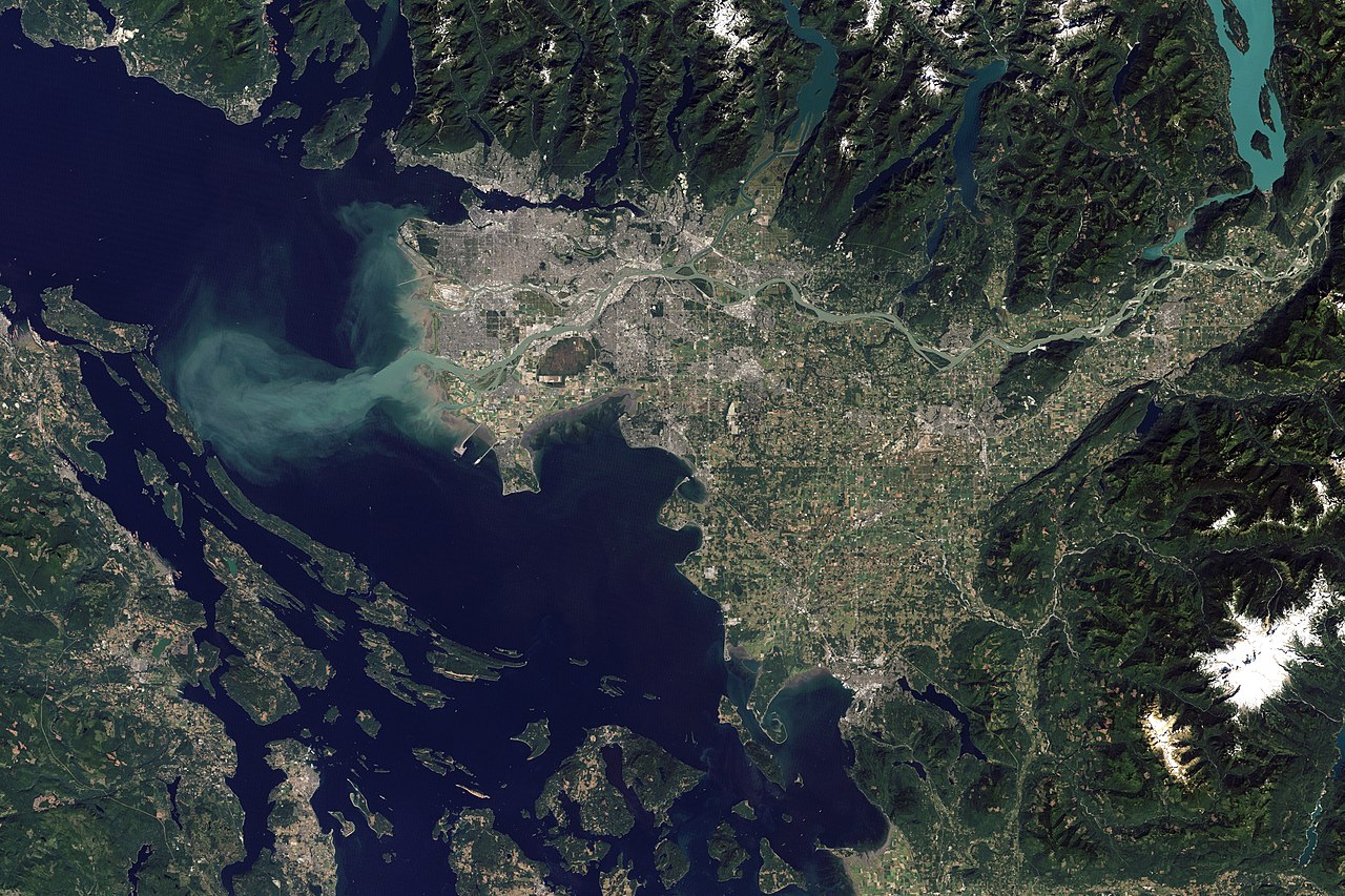
Arising from headwaters around Mount Robson in the Rocky Mountains, the Fraser River starts as a fast-moving stream. The river angles northward around the Columbia Mountains, picking up so much sediment that it appears brown by the time it reaches Quesnel. Near the coast, the river flows over flatter terrain, so it slows down and spreads out. On the final leg of its journey, the Fraser travels along the southern fringe of Vancouver. The Thematic Mapper on the Landsat 5 satellite captured this image of Vancouver on September 7, 2011. Flowing through braided channels, the Fraser River meanders toward the sea, emptying through multiple outlets. The river’s abundant sediment forms a distinct plume west of Vancouver, extending across the Strait of Georgia to the eastern shore of Valdes Island. In fact, the Fraser River carries an estimated 20 million metric tons of sediment to the Pacific Ocean each year. Some of it drops out of the water before reaching the ocean, and this steady delivery has contributed to the landscape of Vancouver. The muddy surface of the river often hides the complex, turbulent activity below. The mouth of the Fraser River is an estuary—a place where freshwater from rivers mixes with salt water from the ocean. But this estuary differs from some others in North America. In the San Francisco Bay, the Chesapeake Bay, and the mouth of the Hudson River, the mixing of salt and fresh water extends over miles. Near Vancouver, the mixing occurs along an abrupt front spanning just tens of meters. Although the swirling water and thick sediment can confuse salmon, the mixing also expels stagnant water and pollution and draws in oxygen. A salmon-rich river draining into a seafood-rich ocean likely played a role in human settlement along the Fraser. Artifacts in this region suggest that human occupation may have started as long as 16,000 years ago. Unlike many other rivers, the Fraser has not been dammed. But it faces an indirect threat from pine beetle infestation; the subsequent removal of trees may warm the river water, making it inhospitable to the fish. NASA Earth Observatory image created by Robert Simmon and Jesse Allen, using Landsat data provided by the United States Geological Survey. Caption by Michon Scott. Instrument: Landsat 5 - TM Credit: NASA Earth Observatory NASA Goddard Space Flight Center enables NASA’s mission through four scientific endeavors: Earth Science, Heliophysics, Solar System Exploration, and Astrophysics. Goddard plays a leading role in NASA’s accomplishments by contributing compelling scientific knowledge to advance the Agency’s mission. Follow us on Twitter Like us on Facebook Find us on Instagram |
| Fecha | |
| Fuente | The Big Muddy, Western Edition |
| Autor | NASA Goddard Space Flight Center from Greenbelt, MD, USA |
| Otras versiones |
 |
| Posición de la cámara | | Ubicación de esta y otras imágenes en: OpenStreetMap |
|---|
.jpg¶ms=049.252568_N_-123.213501_E_globe:Earth_type:camera_source:Flickr_&language=es)
Licencia
- Eres libre:
- de compartir – de copiar, distribuir y transmitir el trabajo
- de remezclar – de adaptar el trabajo
- Bajo las siguientes condiciones:
- atribución – Debes otorgar el crédito correspondiente, proporcionar un enlace a la licencia e indicar si realizaste algún cambio. Puedes hacerlo de cualquier manera razonable pero no de manera que sugiera que el licenciante te respalda a ti o al uso que hagas del trabajo.
| Esta imagen fue publicada en Flickr por NASA Goddard Photo and Video en https://flickr.com/photos/24662369@N07/6987590721. La imagen fue revisada el 17 de septiembre de 2016 por el robot FlickreviewR y confirmó tener licencia bajo los términos de cc-by-2.0. |
| Este archivo es de dominio público porque fue creado por la NASA. Las políticas sobre copyright de la NASA estipulan que «el material de la NASA no está protegido con copyright a menos que se indique lo contrario». (Políticas sobre copyright de la NASA o Políticas sobre la utilización de imágenes del Jet Propulsion Laboratory). | ||
 |
Advertencias:
|
Historial del archivo
Haz clic sobre una fecha y hora para ver el archivo tal como apareció en ese momento.
| Fecha y hora | Miniatura | Dimensiones | Usuario | Comentario | |
|---|---|---|---|---|---|
| actual | 21:48 17 sep 2016 | | 5559 × 3706 (5,91 MB) | Vanished Account Byeznhpyxeuztibuo | Transferred from Flickr via Flickr2Commons |
Usos del archivo
Las siguientes páginas usan este archivo:
Uso global del archivo
Las wikis siguientes utilizan este archivo:
- Uso en en.wikipedia.org
- Uso en fr.wikipedia.org
- Uso en zh.wikipedia.org
.jpg)