
Archivo:Track map for the Pau street circuit -- 2007.svg

Tamaño de esta previsualización PNG del archivo SVG: 800 × 552 píxeles. Otras resoluciones: 320 × 221 píxeles · 640 × 442 píxeles · 1024 × 707 píxeles · 1280 × 884 píxeles · 2560 × 1767 píxeles · 1424 × 983 píxeles.
Ver la imagen en su resolución original ((Imagen SVG, nominalmente 1424 × 983 pixels, tamaño de archivo: 189 kB))
Resumen
| Descripción |
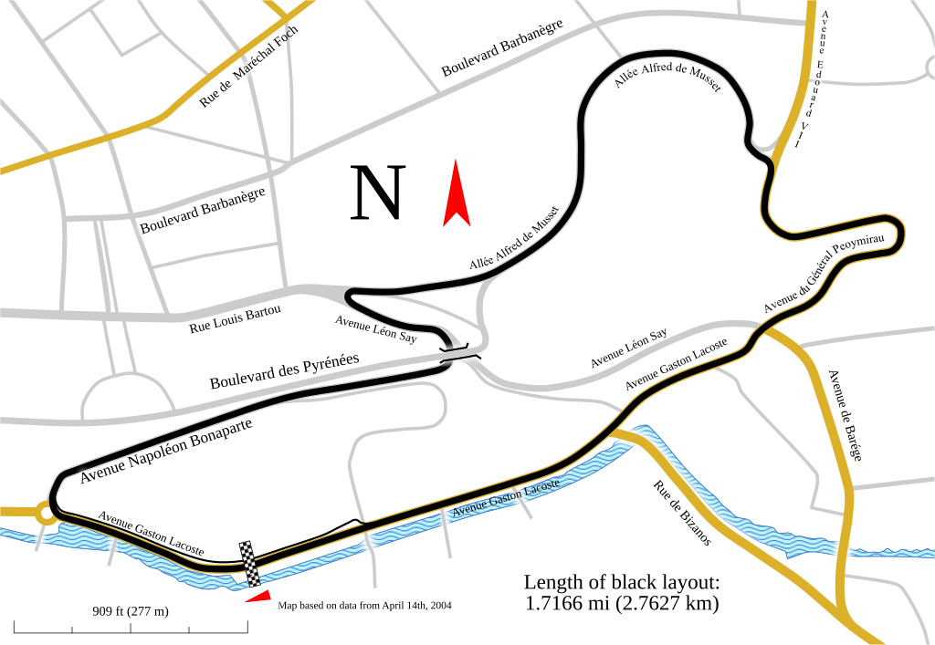
English: Track map for use with Pau Grand Prix. This version shows the track as it was in 2007.
Notes:
|
| Fecha | |
| Fuente | Trabajo propio |
| Autor | Will Pittenger |
| Otras versiones |
Older images by other authors for the same track
Same map, but with different data
|

![]]](http://commons.wikimedia.org/wiki/File:Track_map_for_the_Pau_street_circuit_--_2007.svg)
| Posición de la cámara | | Ubicación de esta y otras imágenes en: OpenStreetMap |
|---|
Licencia
Yo, el titular de los derechos de autor de esta obra, la publico en los términos de la siguiente licencia:
Este archivo se encuentra bajo la licencia Creative Commons Genérica de Atribución/Compartir-Igual 3.0.
- Eres libre:
- de compartir – de copiar, distribuir y transmitir el trabajo
- de remezclar – de adaptar el trabajo
- Bajo las siguientes condiciones:
- atribución – Debes otorgar el crédito correspondiente, proporcionar un enlace a la licencia e indicar si realizaste algún cambio. Puedes hacerlo de cualquier manera razonable pero no de manera que sugiera que el licenciante te respalda a ti o al uso que hagas del trabajo.
- compartir igual – En caso de mezclar, transformar o modificar este trabajo, deberás distribuir el trabajo resultante bajo la misma licencia o una compatible como el original.
Historial del archivo
Haz clic sobre una fecha y hora para ver el archivo tal como apareció en ese momento.
| Fecha y hora | Miniatura | Dimensiones | Usuario | Comentario | |
|---|---|---|---|---|---|
| actual | 03:29 12 feb 2010 | | 1424 × 983 (189 kB) | Will Pittenger | The version being reverted is for editing purposes. This version is the viewable verison |
| 03:28 12 feb 2010 |  | 1424 × 983 (121 kB) | Will Pittenger | One of these days... | |
| 03:26 12 feb 2010 |  | 1424 × 983 (189 kB) | Will Pittenger | Oops. Previous version already had the text on path objects converted into paths. Since a version online is needed that is editable, I have to upload this version. | |
| 03:22 12 feb 2010 |  | 1424 × 983 (189 kB) | Will Pittenger | Found out that pit lane was actually in a different spot and moved it to the correct location. Note: Three text objects are now on paths. This version is for editing only. | |
| 21:06 6 feb 2010 |  | 1424 × 983 (287 kB) | Will Pittenger | The text objects that were on paths are now plain paths. If you need to edit this file, please follow the instructions in the description. | |
| 21:00 6 feb 2010 |  | 1424 × 983 (120 kB) | Will Pittenger | {{Information |Description={{en|1=Track map for use with w:Pau Grand Prix. This version shows the track as it was in w:2007. Notes: *This map has three text objects on paths. MediaWiki/RSVG has a bug causing it to hide all such objects. Henc |
Usos del archivo
Las siguientes páginas usan este archivo:
Uso global del archivo
Las wikis siguientes utilizan este archivo:
- Uso en ast.wikipedia.org
- Uso en cs.wikipedia.org
- Uso en de.wikipedia.org
- Uso en en.wikipedia.org
- Uso en fi.wikipedia.org
- Uso en hu.wikipedia.org
- Uso en it.wikipedia.org
- Uso en ja.wikipedia.org
- Uso en nl.wikipedia.org
- Uso en no.wikipedia.org
- Uso en pt.wikipedia.org
- Uso en ru.wikipedia.org
- Uso en sl.wikipedia.org
- Uso en www.wikidata.org