
Archivo:US Secession map 1861.svg

Tamaño de esta previsualización PNG del archivo SVG: 787 × 483 píxeles. Otras resoluciones: 320 × 196 píxeles · 640 × 393 píxeles · 1024 × 628 píxeles · 1280 × 786 píxeles · 2560 × 1571 píxeles.
Ver la imagen en su resolución original ((Imagen SVG, nominalmente 787 × 483 pixels, tamaño de archivo: 111 kB))
Resumen
{{Information
|Description=
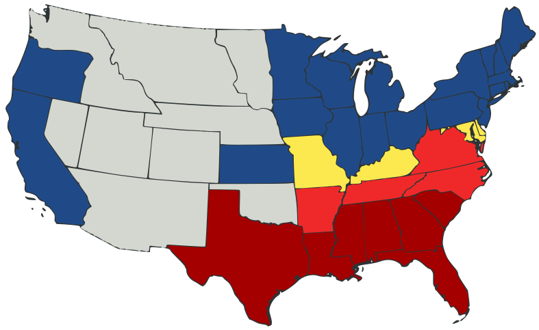
English: United States map of 1861, showing affiliation of states and territories regarding secession from the Union at the start of the American Civil War.
Legend:
States that seceded before April 15, 1861
States that seceded after April 15, 1861
States that permitted slavery, but did not secede
States of the Union where slavery was banned
U.S. territories, under Union Army control
|Date=2007-02-23
|Source=
El código fuente de esta imagen SVG es válido.
Esta imagen vectorial fue creada con Inkscape, y luego editada manualmente
.A trace, retouch, and recolour of Image:Secession Map of the United States, 1861.png by User:Tomf688.
|Author=[[User:ions= |Other fields= }}
Licencia
Este archivo se encuentra bajo la licencia Creative Commons Genérica de Atribución/Compartir-Igual 3.0.
- Eres libre:
- de compartir – de copiar, distribuir y transmitir el trabajo
- de remezclar – de adaptar el trabajo
- Bajo las siguientes condiciones:
- atribución – Debes otorgar el crédito correspondiente, proporcionar un enlace a la licencia e indicar si realizaste algún cambio. Puedes hacerlo de cualquier manera razonable pero no de manera que sugiera que el licenciante te respalda a ti o al uso que hagas del trabajo.
- compartir igual – En caso de mezclar, transformar o modificar este trabajo, deberás distribuir el trabajo resultante bajo la misma licencia o una compatible como el original.
Historial del archivo
Haz clic sobre una fecha y hora para ver el archivo tal como apareció en ese momento.
| Fecha y hora | Miniatura | Dimensiones | Usuario | Comentario | |
|---|---|---|---|---|---|
| actual | 23:47 23 feb 2007 | | 787 × 483 (111 kB) | Tintazul | {{Tintazul |Description=United States map of 1861, show affiliation of states and territories regarding the Secession War (Civil War.) Legend: {{legend|#A40000|States that seceded before April 15, 1861}} {{legend|#EF2929|States that seceded after April 15 |
Usos del archivo
Las siguientes páginas usan este archivo:
Uso global del archivo
Las wikis siguientes utilizan este archivo:
- Uso en ar.wikipedia.org
- Uso en arz.wikipedia.org
- Uso en be.wikipedia.org
- Uso en bg.wikipedia.org
- Uso en bs.wikipedia.org
- Uso en cy.wikipedia.org
- Uso en da.wikipedia.org
- Uso en el.wikipedia.org
- Uso en en.wikipedia.org
- American Civil War
- Irredentism
- Origins of the American Civil War
- User:Jimmuldrow/Sandbox
- Upland South
- User:ArmyAnt/Sandbox
- Presidency of Abraham Lincoln
- Presidency of James Buchanan
- James Buchanan
- Central Confederacy
- User:Themaster1112/sandbox
- User:2know4power/sandbox
- User:LukeRun82
- User:Orser67/Lincoln
- Uso en eu.wikipedia.org
- Uso en gd.wikipedia.org
- Uso en he.wikipedia.org
- Uso en hr.wikipedia.org
- Uso en hy.wikipedia.org
- Uso en it.wikipedia.org
- Uso en ka.wikipedia.org
- Uso en lij.wikipedia.org
- Uso en lt.wikipedia.org
- Uso en ml.wikipedia.org
- Uso en ne.wikipedia.org
- Uso en no.wikipedia.org
- Uso en pl.wikipedia.org
- Uso en pt.wikipedia.org
- Uso en ro.wikipedia.org
- Uso en sh.wikipedia.org
- Uso en simple.wikipedia.org
Ver más uso global de este archivo.