
Archivo:Map -- location of barrages at the mouth of the River Murray.tif

Tamaño de esta previsualización PNG del archivo TIF: 800 × 478 píxeles. Otras resoluciones: 320 × 191 píxeles · 640 × 382 píxeles · 1024 × 611 píxeles · 1280 × 764 píxeles · 2338 × 1396 píxeles.
Ver la imagen en su resolución original (2338 × 1396 píxeles; tamaño de archivo: 12,45 MB; tipo MIME: image/tiff)
Resumen
| Descripción |
English: Satellite image map showing the barrages at the mouth of the River Murray, South Australia |
| Fecha | |
| Fuente | http://location.sa.gov.au/viewer/ |
| Autor | Government of South Australia (Location SA Map Viewer) |
| Posición de la cámara | | Ubicación de esta y otras imágenes en: OpenStreetMap |
|---|
Licencia
Este archivo está disponible bajo la licencia Creative Commons Atribución 4.0 Internacional.
Atribución: Government of South Australia.
The Government of South Australia owns copyright in this work, which it has licensed in keeping with the Open Data Policy initiated by the Australian Government. The Policy includes the direction: "all government agencies should make non-sensitive data open by default, and it should be free, easy to use, and reliable. Agencies should publish anonymised data ... under a Creative Commons BY Attribution licence."
The Government of South Australia owns copyright in this work, which it has licensed in keeping with the Open Data Policy initiated by the Australian Government. The Policy includes the direction: "all government agencies should make non-sensitive data open by default, and it should be free, easy to use, and reliable. Agencies should publish anonymised data ... under a Creative Commons BY Attribution licence."
- Eres libre:
- de compartir – de copiar, distribuir y transmitir el trabajo
- de remezclar – de adaptar el trabajo
- Bajo las siguientes condiciones:
- atribución – Debes otorgar el crédito correspondiente, proporcionar un enlace a la licencia e indicar si realizaste algún cambio. Puedes hacerlo de cualquier manera razonable pero no de manera que sugiera que el licenciante te respalda a ti o al uso que hagas del trabajo.
Historial del archivo
Haz clic sobre una fecha y hora para ver el archivo tal como apareció en ese momento.
| Fecha y hora | Miniatura | Dimensiones | Usuario | Comentario | |
|---|---|---|---|---|---|
| actual | 00:49 4 mar 2021 | 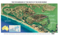 | 2338 × 1396 (12,45 MB) | SCHolar44 | Uploaded a work by Government of South Australia (Location SA Map Viewer) from http://location.sa.gov.au/viewer/ with UploadWizard |
Usos del archivo
La siguiente página usa este archivo:
Uso global del archivo
Las wikis siguientes utilizan este archivo:
- Uso en en.wikipedia.org
- Uso en www.wikidata.org