
Archivo:Peck correction 2003.tif

Tamaño de esta previsualización PNG del archivo TIF: 800 × 497 píxeles. Otras resoluciones: 320 × 199 píxeles · 640 × 398 píxeles · 1024 × 637 píxeles · 1280 × 796 píxeles · 2560 × 1591 píxeles · 8037 × 4996 píxeles.
Ver la imagen en su resolución original (8037 × 4996 píxeles; tamaño de archivo: 153,18 MB; tipo MIME: image/tiff)
Resumen
| Descripción |
English: This figure depicts the northwestern quadrant of the Peter Martyr map as corrected in Peck 2003, p 96, fig 4. Base map from USM, processed via MacOS Pages.
In the figure, roman numerals identify the following features -
Note -
References = Peck DT (May 2003). "The First European Charting of Florida and the Adjacent Shores". Florida Geographer. 34: 82–114. ISSN 0739-0041. Base map = , via the Osher Map Library, University of Southern Maine, call number 244.0001, URI https://oshermaps.org/browse-maps?id=110388. , via the Osher Map Library, University of Southern Maine, call number 244.0001, URI https://oshermaps.org/browse-maps?id=110388. |
| Fecha | |
| Fuente | Trabajo propio |
| Autor | Asdfjrjjj |
Licencia
Yo, el titular de los derechos de autor de esta obra, la publico en los términos de la siguiente licencia:
Este archivo está disponible bajo la licencia Creative Commons Attribution-Share Alike 4.0 International.
- Eres libre:
- de compartir – de copiar, distribuir y transmitir el trabajo
- de remezclar – de adaptar el trabajo
- Bajo las siguientes condiciones:
- atribución – Debes otorgar el crédito correspondiente, proporcionar un enlace a la licencia e indicar si realizaste algún cambio. Puedes hacerlo de cualquier manera razonable pero no de manera que sugiera que el licenciante te respalda a ti o al uso que hagas del trabajo.
- compartir igual – En caso de mezclar, transformar o modificar este trabajo, deberás distribuir el trabajo resultante bajo la misma licencia o una compatible como el original.
Historial del archivo
Haz clic sobre una fecha y hora para ver el archivo tal como apareció en ese momento.
| Fecha y hora | Miniatura | Dimensiones | Usuario | Comentario | |
|---|---|---|---|---|---|
| actual | 23:33 13 sep 2023 | 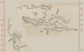 | 8037 × 4996 (153,18 MB) | Asdfjrjjj | Uploaded own work with UploadWizard |
Usos del archivo
La siguiente página usa este archivo:
Uso global del archivo
Las wikis siguientes utilizan este archivo:
- Uso en en.wikipedia.org